Santa Ana elevation
Santa Ana (Huancavelica, Provincia de Castrovirreyna), Peru elevation is 4470 meters and Santa Ana elevation in feet is 14665 ft above sea level [src 1]. Santa Ana is a seat of a third-order administrative division (feature code) with elevation that is 2149 meters (7051 ft) bigger than average city elevation in Peru.
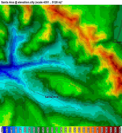
Below is the Elevation map of Santa Ana, which displays elevation range with different colors. Scale of the first map is from 4351 to 5128 m (14275 to 16824 ft) with average elevation of 4642.7 meters (=15232 ft) [note 1]
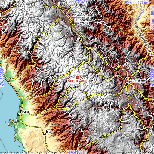
These maps also provides idea of topography and contour of this city, they are displayed at different zoom levels. More info about maps, scale and edge coordinates you can find below images.
| \ | Map #1 | Topo.Map |
| Scale [m] | 4351..5128 m | × |
| Scale [ft] | 14275..16824 ft | × |
| Average | 4642.7 m = 15232 ft | × |
| Width | 9.52 km = 5.9 mi | 304.6 km = 189.3 mi |
| Height | 9.52 km = 5.9 mi | 304.6 km = 189.3 mi |
| ↑Max Latitude | -13.007186° | -11.6764° |
| Latitude at center | -13.05° | -13.05° |
| ↓Min Latitude | -13.092807° | -14.41601° |
| ← Min Longitude | -75.177275° | -76.53958° |
| Longitude center | -75.13333° | -75.13333° |
| →Max Longitude | -75.089385° | -73.72708° |
Nearby cities:
Cities around Santa Ana sort by population:
• Huancavelica elevation 3704 m
34.5 km,  30°
30°
• Chupamarca 3372 m
50.6 km,  272°
272°
• Anchonga 3686 m
50.5 km,  68°
68°
• Lircay 3510 m
45.5 km,  82°
82°
• Ticrapo 3572 m
45.3 km,  222°
222°
• Huachos 4023 m
44.7 km,  248°
248°
• Arma 3938 m
44 km,  260°
260°
• Mollepampa 2725 m
40.1 km,  226°
226°
• Cocas 3444 m
34.9 km, 226°
• Pilpichaca 4095 m
34 km,  154°
154°
• Castrovirreyna 4143 m
31.2 km, 219°
• Huachocolpa 3973 m
20.5 km, 83°
Multilingual:
 En español:
Santa Ana elevación 4470 m.
 En France:
Santa Ana élévation 4470 m.
 Auf Deutsch:
Santa Ana höhe über dem Meeresspiegel ist 4470 m.

Sources and notes:
- [note 1] Map square and city borders are not equal. Map elevation data is calculated only from area inside that square.
- [src 1] Elevation data from geonames database provided with same terms of usage.
- [src 2] The elevation map of Santa Ana is generated using elevation data from NASA's 3 arcsec (90m) resolution SRTM data.
- [src 3] Base (background) map © OpenStreetMap contributors tiles are generated by Geofabrik and OpenTopoMap.
Copyright & License:
This Santa Ana Elevation Map is licensed under CC BY-SA. You may reuse any part from this page, if you give a proper credit by linking to this URL:
 More info on terms of use page.