Socos elevation
Socos (Ayacucho, Provincia de Huamanga), Peru elevation is 3398 meters and Socos elevation in feet is 11148 ft above sea level [src 1]. Socos is a seat of a third-order administrative division (feature code) with elevation that is 1077 meters (3533 ft) bigger than average city elevation in Peru.
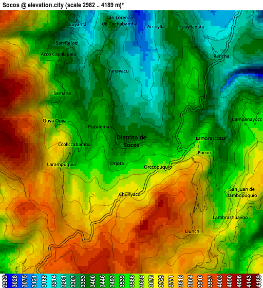
Below is the Elevation map of Socos, which displays elevation range with different colors. Scale of the first map is from 2982 to 4189 m (9783 to 13743 ft) with average elevation of 3585.9 meters (=11765 ft) [note 1]
These maps also provides idea of topography and contour of this city, they are displayed at different zoom levels. More info about maps, scale and edge coordinates you can find below images.
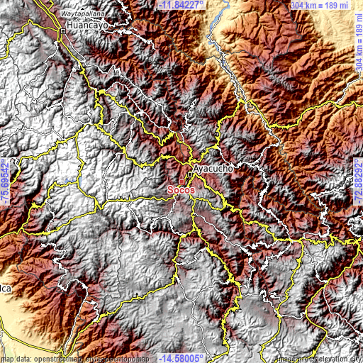
| \ | Map #1 | Topo.Map |
| Scale [m] | 2982..4189 m | × |
| Scale [ft] | 9783..13743 ft | × |
| Average | 3585.9 m = 11765 ft | × |
| Width | 9.51 km = 5.9 mi | 304.4 km = 189.1 mi |
| Height | 9.51 km = 5.9 mi | 304.4 km = 189.1 mi |
| ↑Max Latitude | -13.172215° | -11.84227° |
| Latitude at center | -13.215° | -13.215° |
| ↓Min Latitude | -13.257778° | -14.58005° |
| ← Min Longitude | -74.333115° | -75.69542° |
| Longitude center | -74.28917° | -74.28917° |
| →Max Longitude | -74.245225° | -72.88292° |
Nearby cities:
Cities around Socos sort by population:
• Ayacucho elevation 2743 m
9.5 km,  48°
48°
• Macachacra 3121 m
27.5 km,  20°
20°
• Acocro 3251 m
26.6 km,  90°
90°
• Huamanguilla 3225 m
25.7 km,  27°
27°
• Quinua 3286 m
24.6 km,  41°
41°
• Antaparco 2759 m
20.6 km,  319°
319°
• Tambillo 3081 m
19.4 km,  82°
82°
• Pacaycasa 2563 m
19.4 km, 24°
• Chiara 3506 m
11.2 km,  125°
125°
• Ticllas 3277 m
10.3 km,  332°
332°
• Carmen Alto 2890 m
7.9 km,  62°
62°
• Vinchos 3135 m
7.5 km,  247°
247°
Multilingual:
 En español:
Socos elevación 3398 m.
 En France:
Socos élévation 3398 m.


Sources and notes:
- [note 1] Map square and city borders are not equal. Map elevation data is calculated only from area inside that square.
- [src 1] Elevation data from geonames database provided with same terms of usage.
- [src 2] The elevation map of Socos is generated using elevation data from NASA's 3 arcsec (90m) resolution SRTM data.
- [src 3] Base (background) map © OpenStreetMap contributors tiles are generated by Geofabrik and OpenTopoMap.
Copyright & License:
This Socos Elevation Map is licensed under CC BY-SA. You may reuse any part from this page, if you give a proper credit by linking to this URL:
 More info on terms of use page.