Upahuacho elevation
Upahuacho (Ayacucho, Provincia de Parinacochas), Peru elevation is 3247 meters and Upahuacho elevation in feet is 10653 ft above sea level [src 1]. Upahuacho is a seat of a third-order administrative division (feature code) with elevation that is 926 meters (3038 ft) bigger than average city elevation in Peru.
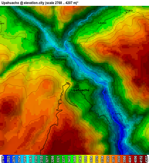
Below is the Elevation map of Upahuacho, which displays elevation range with different colors. Scale of the first map is from 2768 to 4207 m (9081 to 13802 ft) with average elevation of 3574.3 meters (=11727 ft) [note 1]
These maps also provides idea of topography and contour of this city, they are displayed at different zoom levels. More info about maps, scale and edge coordinates you can find below images.
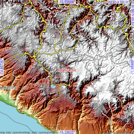
| \ | Map #1 | Topo.Map |
| Scale [m] | 2768..4207 m | × |
| Scale [ft] | 9081..13802 ft | × |
| Average | 3574.3 m = 11727 ft | × |
| Width | 9.44 km = 5.9 mi | 302.2 km = 187.8 mi |
| Height | 9.44 km = 5.9 mi | 302.2 km = 187.8 mi |
| ↑Max Latitude | -14.859198° | -13.53854° |
| Latitude at center | -14.90167° | -14.90167° |
| ↓Min Latitude | -14.944133° | -16.25622° |
| ← Min Longitude | -73.445055° | -74.80736° |
| Longitude center | -73.40111° | -73.40111° |
| →Max Longitude | -73.357165° | -71.99486° |
Nearby cities:
Cities around Upahuacho sort by population:
• Coracora elevation 3219 m
43.6 km,  250°
250°
• Corculla 3482 m
45.5 km,  151°
151°
• Chumpi 3019 m
45 km,  240°
240°
• Incuyo 3295 m
43.4 km,  206°
206°
• Pausa 2516 m
42.5 km,  171°
171°
• Quilcata 3374 m
38.9 km,  188°
188°
• Oyolo 3394 m
38.6 km,  143°
143°
• Lampa 2797 m
31.9 km, 169°
• Colta 3227 m
31.1 km,  158°
158°
• Marcabamba 2584 m
28.4 km, 167°
• Aniso 3602 m
15.7 km,  48°
48°
• Pacapausa 2796 m
6.6 km, 147°
Multilingual:
 En español:
Upahuacho elevación 3247 m.
 En France:
Upahuacho élévation 3247 m.
 Auf Deutsch:
Upahuacho höhe über dem Meeresspiegel ist 3247 m.

Sources and notes:
- [note 1] Map square and city borders are not equal. Map elevation data is calculated only from area inside that square.
- [src 1] Elevation data from geonames database provided with same terms of usage.
- [src 2] The elevation map of Upahuacho is generated using elevation data from NASA's 3 arcsec (90m) resolution SRTM data.
- [src 3] Base (background) map © OpenStreetMap contributors tiles are generated by Geofabrik and OpenTopoMap.
Copyright & License:
This Upahuacho Elevation Map is licensed under CC BY-SA. You may reuse any part from this page, if you give a proper credit by linking to this URL:
 More info on terms of use page.