Agallpampa elevation
Agallpampa (La Libertad, Provincia de Otuzco), Peru elevation is 3087 meters and Agallpampa elevation in feet is 10128 ft above sea level [src 1]. Agallpampa is a seat of a third-order administrative division (feature code) with elevation that is 766 meters (2513 ft) bigger than average city elevation in Peru.
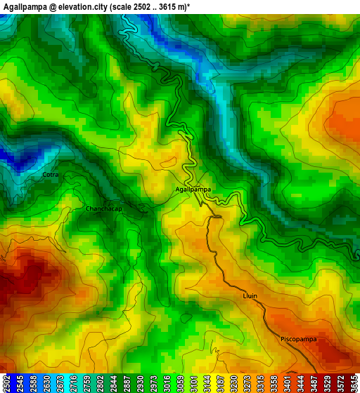
Below is the Elevation map of Agallpampa, which displays elevation range with different colors. Scale of the first map is from 2502 to 3615 m (8209 to 11860 ft) with average elevation of 3047.4 meters (=9998 ft) [note 1]
These maps also provides idea of topography and contour of this city, they are displayed at different zoom levels. More info about maps, scale and edge coordinates you can find below images.
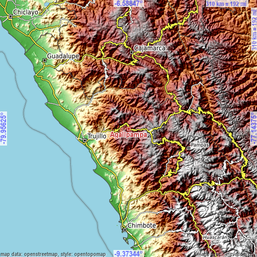
| \ | Map #1 | Topo.Map |
| Scale [m] | 2502..3615 m | × |
| Scale [ft] | 8209..11860 ft | × |
| Average | 3047.4 m = 9998 ft | × |
| Width | 9.68 km = 6 mi | 309.7 km = 192.4 mi |
| Height | 9.68 km = 6 mi | 309.7 km = 192.4 mi |
| ↑Max Latitude | -7.939808° | -6.58847° |
| Latitude at center | -7.98333° | -7.98333° |
| ↓Min Latitude | -8.026847° | -9.37344° |
| ← Min Longitude | -78.593945° | -79.95625° |
| Longitude center | -78.55° | -78.55° |
| →Max Longitude | -78.506055° | -77.14375° |
Nearby cities:
Cities around Agallpampa sort by population:
• Otuzco elevation 3006 m
10 km,  338°
338°
• Quiruvilca 4130 m
38.6 km,  87°
87°
• Huaranchal 2345 m
35.1 km,  18°
18°
• Sinsicap 3138 m
29.1 km,  304°
304°
• Simbal 589 m
29 km,  271°
271°
• Poroto 644 m
24.2 km,  262°
262°
• Usquil 3022 m
23.6 km,  38°
38°
• Charat 2554 m
20 km,  33°
33°
• La Cuesta 2036 m
19.8 km,  291°
291°
• Carabamba 3482 m
16.5 km,  206°
206°
• Salpo 3309 m
7.6 km, 255°
• Mache 3415 m
5.9 km,  161°
161°
Multilingual:
 En español:
Agallpampa elevación 3087 m.
 En France:
Agallpampa élévation 3087 m.
 Auf Deutsch:
Agallpampa höhe über dem Meeresspiegel ist 3087 m.

Sources and notes:
- [note 1] Map square and city borders are not equal. Map elevation data is calculated only from area inside that square.
- [src 1] Elevation data from geonames database provided with same terms of usage.
- [src 2] The elevation map of Agallpampa is generated using elevation data from NASA's 3 arcsec (90m) resolution SRTM data.
- [src 3] Base (background) map © OpenStreetMap contributors tiles are generated by Geofabrik and OpenTopoMap.
Copyright & License:
This Agallpampa Elevation Map is licensed under CC BY-SA. You may reuse any part from this page, if you give a proper credit by linking to this URL:
 More info on terms of use page.