Ayabaca elevation
Ayabaca (Piura, Provincia de Ayabaca), Peru elevation is 2715 meters and Ayabaca elevation in feet is 8907 ft above sea level [src 1]. Ayabaca is a seat of a third-order administrative division (feature code) with elevation that is 394 meters (1293 ft) bigger than average city elevation in Peru.
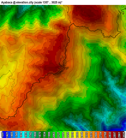
Below is the Elevation map of Ayabaca, which displays elevation range with different colors. Scale of the first map is from 1357 to 3025 m (4452 to 9925 ft) with average elevation of 2344.6 meters (=7692 ft) [note 1]
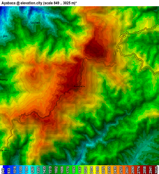
These maps also provides idea of topography and contour of this city, they are displayed at different zoom levels. More info about maps, scale and edge coordinates you can find below images.
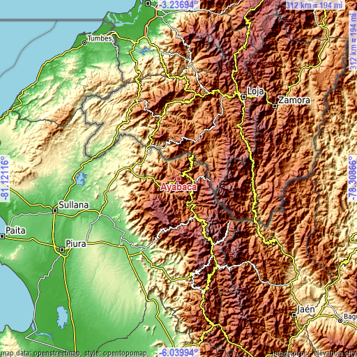
| \ | Map #1 | Map #2 | Topo.Map |
| Scale [m] | 1357..3025 m | 849..3025 m | × |
| Scale [ft] | 4452..9925 ft | 2785..9925 ft | × |
| Average | 2344.6 m = 7692 ft | 1995.3 m = 6546 ft | × |
| Width | 9.74 km = 6.1 mi | 19.48 km = 12.1 mi | 311.7 km = 193.7 mi |
| Height | 9.74 km = 6.1 mi | 19.48 km = 12.1 mi | 311.7 km = 193.7 mi |
| ↑Max Latitude | -4.596027° | -4.552222° | -3.23694° |
| Latitude at center | -4.63983° | -4.63983° | -4.63983° |
| ↓Min Latitude | -4.68363° | -4.727427° | -6.03994° |
| ← Min Longitude | -79.758855° | -79.802801° | -81.12116° |
| Longitude center | -79.71491° | -79.71491° | -79.71491° |
| →Max Longitude | -79.670965° | -79.627019° | -78.30866° |
Nearby cities:
Cities around Ayabaca sort by population:
• Las Lomas elevation 242 m
59 km,  268°
268°
• Paltashaco 827 m
54.4 km,  200°
200°
• Santo Domingo 1545 m
46.4 km, 202°
• Chalaco 2260 m
45.2 km,  191°
191°
• Frias 1668 m
41.3 km,  218°
218°
• Pacaipampa 1953 m
39.8 km,  172°
172°
• Suyo 406 m
34.9 km,  293°
293°
• Sapillica 1440 m
33.4 km,  242°
242°
• Paimas 568 m
25.5 km, 273°
• Lagunas 2176 m
22 km, 220°
• Montero 1081 m
12.6 km, 274°
• Jilili 1280 m
11.1 km,  304°
304°
Multilingual:
 En español:
Ayabaca elevación 2715 m.
 En France:
Ayabaca élévation 2715 m.
 Auf Deutsch:
Ayabaca höhe über dem Meeresspiegel ist 2715 m.

Sources and notes:
- [note 1] Map square and city borders are not equal. Map elevation data is calculated only from area inside that square.
- [src 1] Elevation data from geonames database provided with same terms of usage.
- [src 2] The elevation map of Ayabaca is generated using elevation data from NASA's 3 arcsec (90m) resolution SRTM data.
- [src 3] Base (background) map © OpenStreetMap contributors tiles are generated by Geofabrik and OpenTopoMap.
Copyright & License:
This Ayabaca Elevation Map is licensed under CC BY-SA. You may reuse any part from this page, if you give a proper credit by linking to this URL:
 More info on terms of use page.