Cabana elevation
Cabana (Ancash, Provincia de Pallasca), Peru elevation is 2567 meters and Cabana elevation in feet is 8422 ft above sea level [src 1]. Cabana is a seat of a third-order administrative division (feature code) with elevation that is 246 meters (807 ft) bigger than average city elevation in Peru.
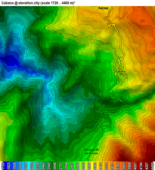
Below is the Elevation map of Cabana, which displays elevation range with different colors. Scale of the first map is from 1720 to 4400 m (5643 to 14436 ft) with average elevation of 2896.7 meters (=9504 ft) [note 1]
These maps also provides idea of topography and contour of this city, they are displayed at different zoom levels. More info about maps, scale and edge coordinates you can find below images.
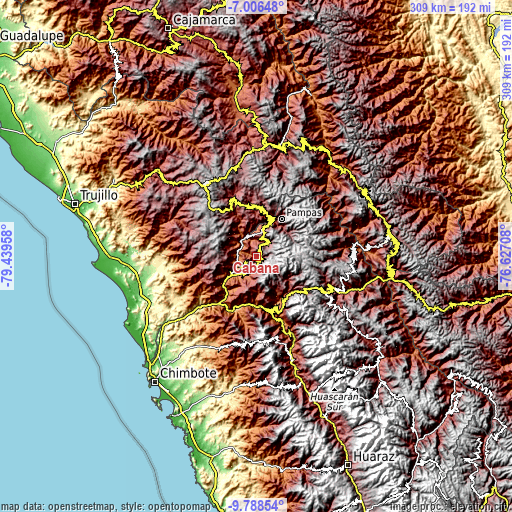
| \ | Map #1 | Topo.Map |
| Scale [m] | 1720..4400 m | × |
| Scale [ft] | 5643..14436 ft | × |
| Average | 2896.7 m = 9504 ft | × |
| Width | 9.67 km = 6 mi | 309.3 km = 192.2 mi |
| Height | 9.67 km = 6 mi | 309.4 km = 192.3 mi |
| ↑Max Latitude | -8.356524° | -7.00648° |
| Latitude at center | -8.4° | -8.4° |
| ↓Min Latitude | -8.443471° | -9.78854° |
| ← Min Longitude | -78.077275° | -79.43958° |
| Longitude center | -78.03333° | -78.03333° |
| →Max Longitude | -77.989385° | -76.62708° |
Nearby cities:
Cities around Cabana sort by population:
• Pampas elevation 3162 m
26.6 km,  33°
33°
• Conchucos 3244 m
25 km,  53°
53°
• Corongo 2594 m
24.1 km,  147°
147°
• Mollepata 2399 m
24.1 km,  22°
22°
• Bambas 2748 m
22.5 km,  170°
170°
• Aco 3304 m
22.2 km,  131°
131°
• Lacabamba 3439 m
20.9 km,  44°
44°
• Pallasca 2589 m
16.8 km,  6°
6°
• Huacaschuque 3277 m
11.7 km, 18°
• Tauca 3057 m
9.4 km,  191°
191°
• Huandoval 3214 m
9.2 km, 36°
• Bolognesi 2660 m
6.7 km,  326°
326°
Multilingual:
 En español:
Cabana elevación 2567 m.
 En France:
Cabana élévation 2567 m.


Sources and notes:
- [note 1] Map square and city borders are not equal. Map elevation data is calculated only from area inside that square.
- [src 1] Elevation data from geonames database provided with same terms of usage.
- [src 2] The elevation map of Cabana is generated using elevation data from NASA's 3 arcsec (90m) resolution SRTM data.
- [src 3] Base (background) map © OpenStreetMap contributors tiles are generated by Geofabrik and OpenTopoMap.
Copyright & License:
This Cabana Elevation Map is licensed under CC BY-SA. You may reuse any part from this page, if you give a proper credit by linking to this URL:
 More info on terms of use page.