Chachapoyas elevation
Chachapoyas (Amazonas, Provincia de Chachapoyas), Peru elevation is 2360 meters and Chachapoyas elevation in feet is 7743 ft above sea level [src 1]. Chachapoyas is a seat of a first-order administrative division (feature code) with elevation that is 39 meters (128 ft) bigger than average city elevation in Peru.
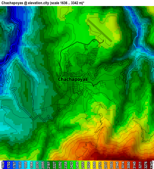
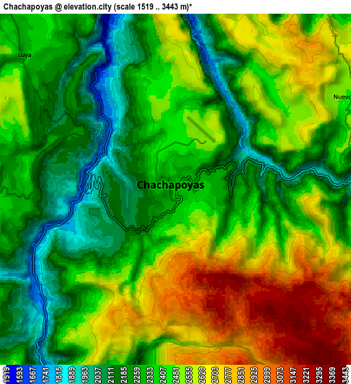
Below is the Elevation map of Chachapoyas, which displays elevation range with different colors. Scale of the first map is from 1636 to 3342 m (5367 to 10965 ft) with average elevation of 2314.8 meters (=7594 ft) [note 1]
These maps also provides idea of topography and contour of this city, they are displayed at different zoom levels. More info about maps, scale and edge coordinates you can find below images.
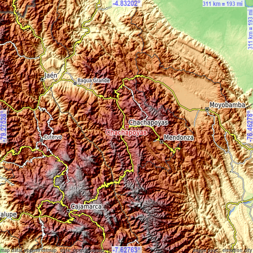
| \ | Map #1 | Map #2 | Topo.Map |
| Scale [m] | 1636..3342 m | 1519..3443 m | × |
| Scale [ft] | 5367..10965 ft | 4984..11296 ft | × |
| Average | 2314.8 m = 7594 ft | 2425.1 m = 7956 ft | × |
| Width | 9.71 km = 6 mi | 19.43 km = 12.1 mi | 310.8 km = 193.1 mi |
| Height | 9.71 km = 6 mi | 19.43 km = 12.1 mi | 310.9 km = 193.2 mi |
| ↑Max Latitude | -6.188003° | -6.144311° | -4.83202° |
| Latitude at center | -6.23169° | -6.23169° | -6.23169° |
| ↓Min Latitude | -6.275374° | -6.319054° | -7.62763° |
| ← Min Longitude | -77.912975° | -77.956921° | -79.27528° |
| Longitude center | -77.86903° | -77.86903° | -77.86903° |
| →Max Longitude | -77.825085° | -77.781139° | -76.46278° |
Nearby cities:
Cities around Chachapoyas sort by population:
• Tingo elevation 1946 m
16.3 km,  196°
196°
• Magdalena 1910 m
16.1 km,  192°
192°
• Soloco 2397 m
14.2 km,  103°
103°
• Daguas 2226 m
14.2 km,  87°
87°
• Lamud 2327 m
14.1 km,  318°
318°
• Colcamar 2323 m
13.8 km,  235°
235°
• Maino 2341 m
11.7 km, 185°
• Luya 2311 m
11.3 km,  311°
311°
• Inguilpata 2402 m
9.8 km,  264°
264°
• Lonya Chico 2296 m
9.7 km,  270°
270°
• Levanto 2656 m
9.1 km, 200°
• Huancas 2590 m
6.4 km,  3°
3°
Multilingual:
 En español:
Chachapoyas elevación 2360 m.
 En France:
Chachapoyas élévation 2360 m.
 Auf Deutsch:
Chachapoyas höhe über dem Meeresspiegel ist 2360 m.

Sources and notes:
- [note 1] Map square and city borders are not equal. Map elevation data is calculated only from area inside that square.
- [src 1] Elevation data from geonames database provided with same terms of usage.
- [src 2] The elevation map of Chachapoyas is generated using elevation data from NASA's 3 arcsec (90m) resolution SRTM data.
- [src 3] Base (background) map © OpenStreetMap contributors tiles are generated by Geofabrik and OpenTopoMap.
Copyright & License:
This Chachapoyas Elevation Map is licensed under CC BY-SA. You may reuse any part from this page, if you give a proper credit by linking to this URL:
 More info on terms of use page.