Chicama elevation
Chicama (La Libertad, Ascope), Peru elevation is 131 meters and Chicama elevation in feet is 430 ft above sea level [src 1]. Chicama is a seat of a third-order administrative division (feature code) with elevation that is 2190 meters (7185 ft) smaller than average city elevation in Peru.
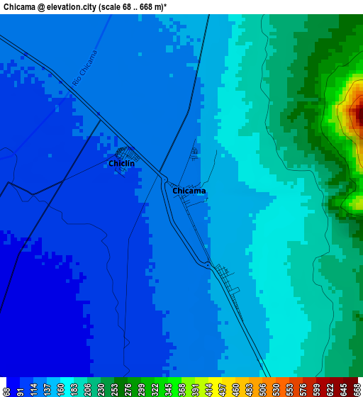
Below is the Elevation map of Chicama, which displays elevation range with different colors. Scale of the first map is from 68 to 668 m (223 to 2192 ft) with average elevation of 152.1 meters (=499 ft) [note 1]
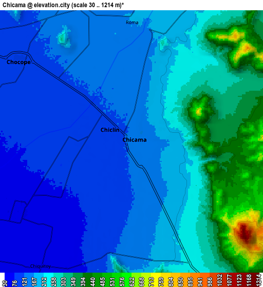
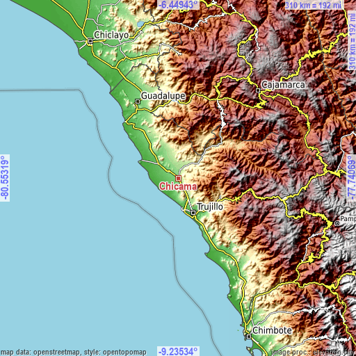
These maps also provides idea of topography and contour of this city, they are displayed at different zoom levels. More info about maps, scale and edge coordinates you can find below images.
| \ | Map #1 | Map #2 | Topo.Map |
| Scale [m] | 68..668 m | 30..1214 m | × |
| Scale [ft] | 223..2192 ft | 98..3983 ft | × |
| Average | 152.1 m = 499 ft | 209 m = 686 ft | × |
| Width | 9.68 km = 6 mi | 19.36 km = 12 mi | 309.8 km = 192.5 mi |
| Height | 9.68 km = 6 mi | 19.36 km = 12 mi | 309.8 km = 192.5 mi |
| ↑Max Latitude | -7.801184° | -7.757643° | -6.44943° |
| Latitude at center | -7.84472° | -7.84472° | -7.84472° |
| ↓Min Latitude | -7.888252° | -7.931779° | -9.23534° |
| ← Min Longitude | -79.190885° | -79.234831° | -80.55319° |
| Longitude center | -79.14694° | -79.14694° | -79.14694° |
| →Max Longitude | -79.102995° | -79.059049° | -77.74069° |
Nearby cities:
Cities around Chicama sort by population:
• Trujillo elevation 31 m
32.8 km,  156°
156°
• Chocope 109 m
10.1 km,  305°
305°
• Laredo 97 m
34.1 km,  142°
142°
• Moche 13 m
39.3 km, 157°
• Santiago de Cao 18 m
16.3 km,  218°
218°
• Paiján 93 m
21.1 km, 306°
• Ascope 231 m
15.1 km,  16°
16°
• Buenos Aires 13 m
34.7 km, 160°
• El Porvenir 88 m
31.1 km,  148°
148°
• La Esperanza 101 m
28.2 km, 156°
• Huanchaco 15 m
26.7 km,  172°
172°
• Casa Grande 147 m
12 km,  338°
338°
Multilingual:
 En español:
Chicama elevación 131 m.
 En France:
Chicama élévation 131 m.


Sources and notes:
- [note 1] Map square and city borders are not equal. Map elevation data is calculated only from area inside that square.
- [src 1] Elevation data from geonames database provided with same terms of usage.
- [src 2] The elevation map of Chicama is generated using elevation data from NASA's 3 arcsec (90m) resolution SRTM data.
- [src 3] Base (background) map © OpenStreetMap contributors tiles are generated by Geofabrik and OpenTopoMap.
Copyright & License:
This Chicama Elevation Map is licensed under CC BY-SA. You may reuse any part from this page, if you give a proper credit by linking to this URL:
 More info on terms of use page.