Chimbote elevation
Chimbote (Ancash, Provincia de Santa), Peru elevation is 9 meters and Chimbote elevation in feet is 30 ft above sea level [src 1]. Chimbote is a seat of a third-order administrative division (feature code) with elevation that is 2312 meters (7585 ft) smaller than average city elevation in Peru.
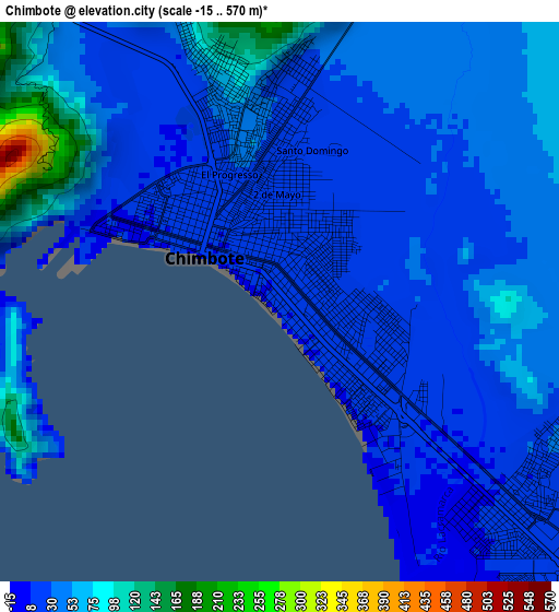
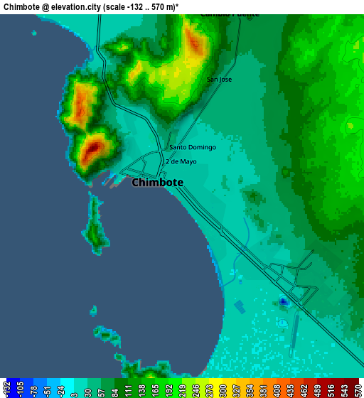
Below is the Elevation map of Chimbote, which displays elevation range with different colors. Scale of the first map is from -15 to 570 m (-49 to 1870 ft) with average elevation of 38.8 meters (=127 ft) [note 1]
These maps also provides idea of topography and contour of this city, they are displayed at different zoom levels. More info about maps, scale and edge coordinates you can find below images.
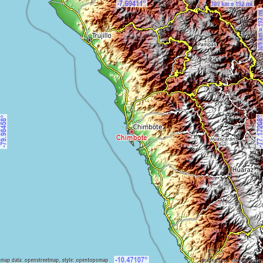
| \ | Map #1 | Map #2 | Topo.Map |
| Scale [m] | -15..570 m | -132..570 m | × |
| Scale [ft] | -49..1870 ft | -433..1870 ft | × |
| Average | 38.8 m = 127 ft | 80.4 m = 264 ft | × |
| Width | 9.65 km = 6 mi | 19.3 km = 12 mi | 308.8 km = 191.9 mi |
| Height | 9.65 km = 6 mi | 19.3 km = 12 mi | 308.8 km = 191.9 mi |
| ↑Max Latitude | -9.041883° | -8.998482° | -7.69411° |
| Latitude at center | -9.08528° | -9.08528° | -9.08528° |
| ↓Min Latitude | -9.128671° | -9.172057° | -10.47107° |
| ← Min Longitude | -78.622275° | -78.666221° | -79.98458° |
| Longitude center | -78.57833° | -78.57833° | -78.57833° |
| →Max Longitude | -78.534385° | -78.490439° | -77.17208° |
Nearby cities:
Cities around Chimbote sort by population:
• Coishco elevation 20 m
8 km,  329°
329°
• Puerto Santa 5 m
13.2 km, 325°
• Macate 2127 m
64.9 km,  56°
56°
• Chao 81 m
61.3 km,  349°
349°
• Casma 49 m
52.9 km,  144°
144°
• Puerto Casma 5 m
47.2 km,  152°
152°
• Moro 493 m
43.9 km,  97°
97°
• Nepeña 142 m
26 km,  111°
111°
• Samanco 8 m
21.6 km,  155°
155°
• Guadalupito 33 m
15.8 km,  341°
341°
• Santa 27 m
11.4 km, 341°
• Buenos Aires 73 m
9.9 km,  115°
115°
Multilingual:
 En español:
Chimbote elevación 9 m.
 En France:
Chimbote élévation 9 m.


Sources and notes:
- [note 1] Map square and city borders are not equal. Map elevation data is calculated only from area inside that square.
- [src 1] Elevation data from geonames database provided with same terms of usage.
- [src 2] The elevation map of Chimbote is generated using elevation data from NASA's 3 arcsec (90m) resolution SRTM data.
- [src 3] Base (background) map © OpenStreetMap contributors tiles are generated by Geofabrik and OpenTopoMap.
Copyright & License:
This Chimbote Elevation Map is licensed under CC BY-SA. You may reuse any part from this page, if you give a proper credit by linking to this URL:
 More info on terms of use page.