Chota elevation
Chota (Cajamarca, Provincia de Chota), Peru elevation is 2390 meters and Chota elevation in feet is 7841 ft above sea level [src 1]. Chota is a seat of a third-order administrative division (feature code) with elevation that is 69 meters (226 ft) bigger than average city elevation in Peru.
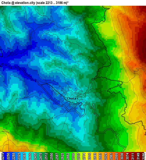
Below is the Elevation map of Chota, which displays elevation range with different colors. Scale of the first map is from 2213 to 3186 m (7260 to 10453 ft) with average elevation of 2528.5 meters (=8296 ft) [note 1]
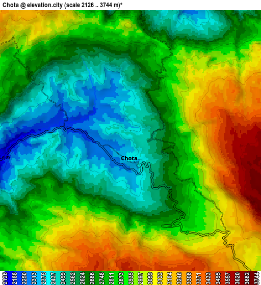
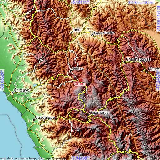
These maps also provides idea of topography and contour of this city, they are displayed at different zoom levels. More info about maps, scale and edge coordinates you can find below images.
| \ | Map #1 | Map #2 | Topo.Map |
| Scale [m] | 2213..3186 m | 2126..3744 m | × |
| Scale [ft] | 7260..10453 ft | 6975..12283 ft | × |
| Average | 2528.5 m = 8296 ft | 2829.9 m = 9284 ft | × |
| Width | 9.71 km = 6 mi | 19.42 km = 12.1 mi | 310.6 km = 193 mi |
| Height | 9.71 km = 6 mi | 19.42 km = 12.1 mi | 310.7 km = 193.1 mi |
| ↑Max Latitude | -6.50634° | -6.462675° | -5.15111° |
| Latitude at center | -6.55° | -6.55° | -6.55° |
| ↓Min Latitude | -6.593657° | -6.637309° | -7.94498° |
| ← Min Longitude | -78.693945° | -78.737891° | -80.05625° |
| Longitude center | -78.65° | -78.65° | -78.65° |
| →Max Longitude | -78.606055° | -78.562109° | -77.24375° |
Nearby cities:
Cities around Chota sort by population:
• Bambamarca elevation 2747 m
19.6 km,  139°
139°
• Cutervo 2881 m
30.1 km,  312°
312°
• Socota 2577 m
29.3 km,  341°
341°
• Cochabamba 1974 m
28.6 km,  285°
285°
• Paccha 2214 m
26.2 km,  77°
77°
• Hualgayoc 3800 m
24.4 km,  171°
171°
• Chalamarca 2377 m
21.1 km,  71°
71°
• Uticyacu 1961 m
19 km,  240°
240°
• Tacabamba 2275 m
18.9 km,  11°
11°
• Chiguirip 2746 m
17.5 km,  328°
328°
• Chugur 2434 m
17 km,  220°
220°
• Lajas 2213 m
9.4 km,  258°
258°
Multilingual:
 En español:
Chota elevación 2390 m.
 En France:
Chota élévation 2390 m.


Sources and notes:
- [note 1] Map square and city borders are not equal. Map elevation data is calculated only from area inside that square.
- [src 1] Elevation data from geonames database provided with same terms of usage.
- [src 2] The elevation map of Chota is generated using elevation data from NASA's 3 arcsec (90m) resolution SRTM data.
- [src 3] Base (background) map © OpenStreetMap contributors tiles are generated by Geofabrik and OpenTopoMap.
Copyright & License:
This Chota Elevation Map is licensed under CC BY-SA. You may reuse any part from this page, if you give a proper credit by linking to this URL:
 More info on terms of use page.