Huicungo elevation
Huicungo (San Martín, Provincia de Mariscal Cáceres), Peru elevation is 301 meters and Huicungo elevation in feet is 988 ft above sea level [src 1]. Huicungo is a populated place (feature code) with elevation that is 2020 meters (6627 ft) smaller than average city elevation in Peru.
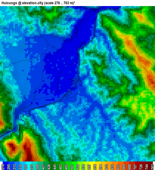
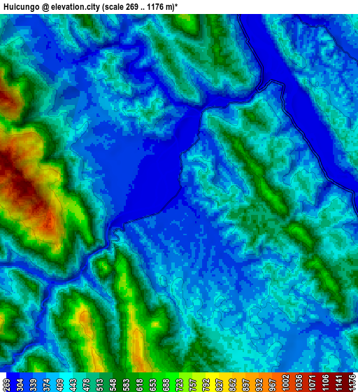
Below is the Elevation map of Huicungo, which displays elevation range with different colors. Scale of the first map is from 276 to 763 m (906 to 2503 ft) with average elevation of 383.5 meters (=1258 ft) [note 1]
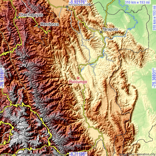
These maps also provides idea of topography and contour of this city, they are displayed at different zoom levels. More info about maps, scale and edge coordinates you can find below images.
| \ | Map #1 | Map #2 | Topo.Map |
| Scale [m] | 276..763 m | 269..1176 m | × |
| Scale [ft] | 906..2503 ft | 883..3858 ft | × |
| Average | 383.5 m = 1258 ft | 454.8 m = 1492 ft | × |
| Width | 9.69 km = 6 mi | 19.39 km = 12 mi | 310.1 km = 192.7 mi |
| Height | 9.69 km = 6 mi | 19.39 km = 12 mi | 310.2 km = 192.7 mi |
| ↑Max Latitude | -7.275011° | -7.231417° | -5.92176° |
| Latitude at center | -7.3186° | -7.3186° | -7.3186° |
| ↓Min Latitude | -7.362185° | -7.405766° | -8.71108° |
| ← Min Longitude | -76.819505° | -76.863451° | -78.18181° |
| Longitude center | -76.77556° | -76.77556° | -76.77556° |
| →Max Longitude | -76.731615° | -76.687669° | -75.36931° |
Nearby cities:
Cities around Huicungo sort by population:
• Juanjuí elevation 278 m
16.6 km,  18°
18°
• Bellavista 319 m
35.6 km,  34°
34°
• Saposoa 311 m
42.8 km,  0°
0°
• Picota 223 m
66 km,  47°
47°
• San Pablo 276 m
59.7 km, 21°
• Caspisapa 232 m
56.3 km,  44°
44°
• Puerto Rico 232 m
53.5 km, 47°
• San Rafael 235 m
46.1 km, 45°
• Piscoyacu 301 m
37.7 km, 1°
• Sacanche 275 m
28.5 km,  13°
13°
• Ledoy 262 m
25.3 km, 33°
• Pajarillo 270 m
17.6 km, 31°
Multilingual:
 En español:
Huicungo elevación 301 m.
 En France:
Huicungo élévation 301 m.
 Auf Deutsch:
Huicungo höhe über dem Meeresspiegel ist 301 m.

Sources and notes:
- [note 1] Map square and city borders are not equal. Map elevation data is calculated only from area inside that square.
- [src 1] Elevation data from geonames database provided with same terms of usage.
- [src 2] The elevation map of Huicungo is generated using elevation data from NASA's 3 arcsec (90m) resolution SRTM data.
- [src 3] Base (background) map © OpenStreetMap contributors tiles are generated by Geofabrik and OpenTopoMap.
Copyright & License:
This Huicungo Elevation Map is licensed under CC BY-SA. You may reuse any part from this page, if you give a proper credit by linking to this URL:
 More info on terms of use page.