La Unión elevation
La Unión (Piura, Provincia de Piura), Peru elevation is 15 meters and La Unión elevation in feet is 49 ft above sea level [src 1]. La Unión is a populated place (feature code) with elevation that is 2306 meters (7566 ft) smaller than average city elevation in Peru.
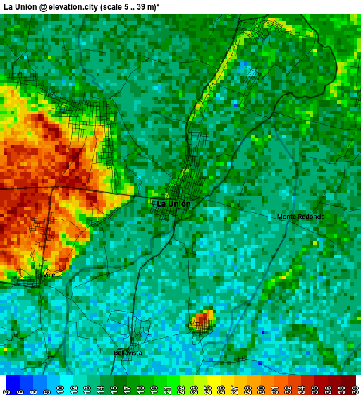
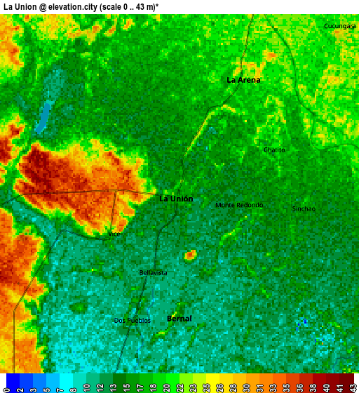
Below is the Elevation map of La Unión, which displays elevation range with different colors. Scale of the first map is from 5 to 39 m (16 to 128 ft) with average elevation of 16.6 meters (=54 ft) [note 1]
These maps also provides idea of topography and contour of this city, they are displayed at different zoom levels. More info about maps, scale and edge coordinates you can find below images.
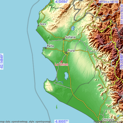
| \ | Map #1 | Map #2 | Topo.Map |
| Scale [m] | 5..39 m | 0..43 m | × |
| Scale [ft] | 16..128 ft | 0..141 ft | × |
| Average | 16.6 m = 54 ft | 17.3 m = 57 ft | × |
| Width | 9.73 km = 6 mi | 19.46 km = 12.1 mi | 311.3 km = 193.4 mi |
| Height | 9.73 km = 6 mi | 19.46 km = 12.1 mi | 311.3 km = 193.4 mi |
| ↑Max Latitude | -5.358568° | -5.314813° | -4.00084° |
| Latitude at center | -5.40232° | -5.40232° | -5.40232° |
| ↓Min Latitude | -5.446069° | -5.489814° | -6.80057° |
| ← Min Longitude | -80.786185° | -80.830131° | -82.14849° |
| Longitude center | -80.74224° | -80.74224° | -80.74224° |
| →Max Longitude | -80.698295° | -80.654349° | -79.33599° |
Nearby cities:
Cities around La Unión sort by population:
• Piura elevation 33 m
26.1 km,  27°
27°
• Sullana 60 m
55.8 km,  6°
6°
• Catacaos 23 m
16.4 km,  23°
23°
• Paita 16 m
54 km,  310°
310°
• Sechura 15 m
19.3 km,  207°
207°
• Salinera Colán 1 m
54.5 km,  318°
318°
• Vice 31 m
4.8 km,  250°
250°
• Bernal 13 m
5.4 km,  189°
189°
• Sojo 50 m
56.4 km,  351°
351°
• Sinchao 11 m
8.5 km,  100°
100°
• La Arena 17 m
7.7 km, 7°
• Dos Pueblos 16 m
6 km, 207°
Multilingual:
 En español:
La Unión elevación 15 m.
 En France:
La Unión élévation 15 m.


Sources and notes:
- [note 1] Map square and city borders are not equal. Map elevation data is calculated only from area inside that square.
- [src 1] Elevation data from geonames database provided with same terms of usage.
- [src 2] The elevation map of La Unión is generated using elevation data from NASA's 3 arcsec (90m) resolution SRTM data.
- [src 3] Base (background) map © OpenStreetMap contributors tiles are generated by Geofabrik and OpenTopoMap.
Copyright & License:
This La Unión Elevation Map is licensed under CC BY-SA. You may reuse any part from this page, if you give a proper credit by linking to this URL:
 More info on terms of use page.