Marcavelica elevation
Marcavelica (Piura, Provincia de Sullana), Peru elevation is 62 meters and Marcavelica elevation in feet is 203 ft above sea level [src 1]. Marcavelica is a seat of a third-order administrative division (feature code) with elevation that is 2259 meters (7411 ft) smaller than average city elevation in Peru.
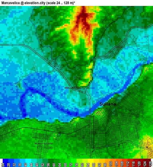
Below is the Elevation map of Marcavelica, which displays elevation range with different colors. Scale of the first map is from 24 to 128 m (79 to 420 ft) with average elevation of 55.4 meters (=182 ft) [note 1]
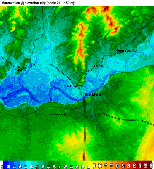
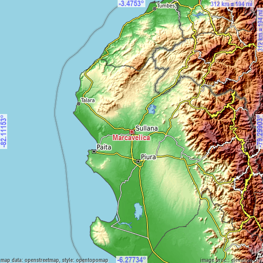
These maps also provides idea of topography and contour of this city, they are displayed at different zoom levels. More info about maps, scale and edge coordinates you can find below images.
| \ | Map #1 | Map #2 | Topo.Map |
| Scale [m] | 24..128 m | 21..150 m | × |
| Scale [ft] | 79..420 ft | 69..492 ft | × |
| Average | 55.4 m = 182 ft | 65.4 m = 215 ft | × |
| Width | 9.74 km = 6.1 mi | 19.47 km = 12.1 mi | 311.6 km = 193.6 mi |
| Height | 9.74 km = 6.1 mi | 19.47 km = 12.1 mi | 311.6 km = 193.6 mi |
| ↑Max Latitude | -4.833992° | -4.790202° | -3.4753° |
| Latitude at center | -4.87778° | -4.87778° | -4.87778° |
| ↓Min Latitude | -4.921565° | -4.965347° | -6.27734° |
| ← Min Longitude | -80.749225° | -80.793171° | -82.11153° |
| Longitude center | -80.70528° | -80.70528° | -80.70528° |
| →Max Longitude | -80.661335° | -80.617389° | -79.29903° |
Nearby cities:
Cities around Marcavelica sort by population:
• Piura elevation 33 m
36.1 km,  167°
167°
• Sullana 60 m
3.7 km,  142°
142°
• Catacaos 23 m
43.3 km,  176°
176°
• Tambo Grande 69 m
40.3 km,  97°
97°
• Querecotillo 53 m
8 km,  56°
56°
• La Huaca 26 m
28.5 km,  262°
262°
• Salitral 52 m
3.5 km,  49°
49°
• Arenal 36 m
35.7 km,  269°
269°
• Amotape 14 m
34.4 km, 269°
• Tamarindo 26 m
29.7 km, 270°
• San Jacinto 44 m
19.3 km,  281°
281°
• Sojo 50 m
12.5 km, 258°
Multilingual:
 En español:
Marcavelica elevación 62 m.
 En France:
Marcavelica élévation 62 m.
 Auf Deutsch:
Marcavelica höhe über dem Meeresspiegel ist 62 m.

Sources and notes:
- [note 1] Map square and city borders are not equal. Map elevation data is calculated only from area inside that square.
- [src 1] Elevation data from geonames database provided with same terms of usage.
- [src 2] The elevation map of Marcavelica is generated using elevation data from NASA's 3 arcsec (90m) resolution SRTM data.
- [src 3] Base (background) map © OpenStreetMap contributors tiles are generated by Geofabrik and OpenTopoMap.
Copyright & License:
This Marcavelica Elevation Map is licensed under CC BY-SA. You may reuse any part from this page, if you give a proper credit by linking to this URL:
 More info on terms of use page.