Obas elevation
Obas (Huanuco, Yarowilca), Peru elevation is 3521 meters and Obas elevation in feet is 11552 ft above sea level [src 1]. Obas is a seat of a third-order administrative division (feature code) with elevation that is 1200 meters (3937 ft) bigger than average city elevation in Peru.
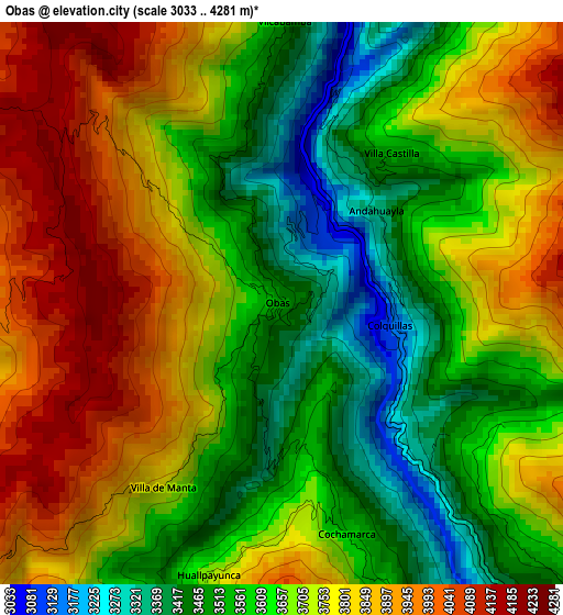
Below is the Elevation map of Obas, which displays elevation range with different colors. Scale of the first map is from 3033 to 4281 m (9951 to 14045 ft) with average elevation of 3692.1 meters (=12113 ft) [note 1]
These maps also provides idea of topography and contour of this city, they are displayed at different zoom levels. More info about maps, scale and edge coordinates you can find below images.
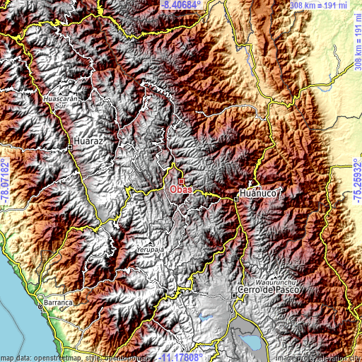
| \ | Map #1 | Topo.Map |
| Scale [m] | 3033..4281 m | × |
| Scale [ft] | 9951..14045 ft | × |
| Average | 3692.1 m = 12113 ft | × |
| Width | 9.63 km = 6 mi | 308.1 km = 191.4 mi |
| Height | 9.63 km = 6 mi | 308.2 km = 191.5 mi |
| ↑Max Latitude | -9.752043° | -8.40684° |
| Latitude at center | -9.79535° | -9.79535° |
| ↓Min Latitude | -9.838652° | -11.17808° |
| ← Min Longitude | -76.709515° | -78.07182° |
| Longitude center | -76.66557° | -76.66557° |
| →Max Longitude | -76.621625° | -75.25932° |
Nearby cities:
Cities around Obas sort by population:
• La Unión elevation 3201 m
15.4 km,  256°
256°
• Jivia 3354 m
25.5 km,  183°
183°
• Quivilla 2970 m
22.8 km,  343°
343°
• Rondos 3568 m
21.1 km,  186°
186°
• Pachas 3440 m
15.2 km,  310°
310°
• Shunqui 3519 m
14.9 km,  297°
297°
• Chuquis 3381 m
13.9 km, 342°
• Yanas 3473 m
12.8 km, 314°
• Sillapata 3444 m
12.6 km,  289°
289°
• Pampamarca 3424 m
10.8 km, 338°
• Chavinillo 3458 m
9.4 km,  138°
138°
• Cahuac 3374 m
7.4 km,  148°
148°
Multilingual:
 En español:
Obas elevación 3521 m.
 En France:
Obas élévation 3521 m.


Sources and notes:
- [note 1] Map square and city borders are not equal. Map elevation data is calculated only from area inside that square.
- [src 1] Elevation data from geonames database provided with same terms of usage.
- [src 2] The elevation map of Obas is generated using elevation data from NASA's 3 arcsec (90m) resolution SRTM data.
- [src 3] Base (background) map © OpenStreetMap contributors tiles are generated by Geofabrik and OpenTopoMap.
Copyright & License:
This Obas Elevation Map is licensed under CC BY-SA. You may reuse any part from this page, if you give a proper credit by linking to this URL:
 More info on terms of use page.