Papayal elevation
Papayal (Tumbes, Provincia de Zarumilla), Peru elevation is 33 meters and Papayal elevation in feet is 108 ft above sea level [src 1]. Papayal is a seat of a third-order administrative division (feature code) with elevation that is 2288 meters (7507 ft) smaller than average city elevation in Peru.
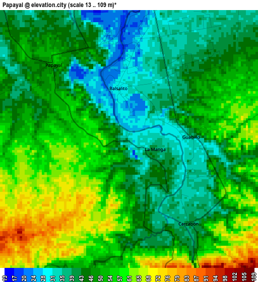
Below is the Elevation map of Papayal, which displays elevation range with different colors. Scale of the first map is from 13 to 109 m (43 to 358 ft) with average elevation of 48.8 meters (=160 ft) [note 1]
These maps also provides idea of topography and contour of this city, they are displayed at different zoom levels. More info about maps, scale and edge coordinates you can find below images.
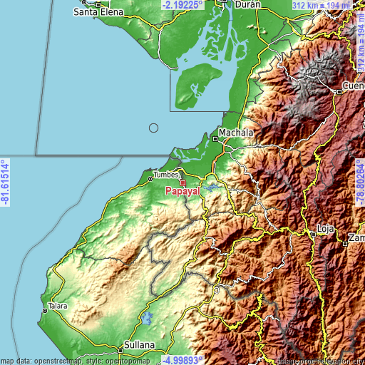
| \ | Map #1 | Topo.Map |
| Scale [m] | 13..109 m | × |
| Scale [ft] | 43..358 ft | × |
| Average | 48.8 m = 160 ft | × |
| Width | 9.75 km = 6.1 mi | 312.1 km = 193.9 mi |
| Height | 9.75 km = 6.1 mi | 312.1 km = 193.9 mi |
| ↑Max Latitude | -3.55281° | -2.19225° |
| Latitude at center | -3.59667° | -3.59667° |
| ↓Min Latitude | -3.640528° | -4.99893° |
| ← Min Longitude | -80.252835° | -81.61514° |
| Longitude center | -80.20889° | -80.20889° |
| →Max Longitude | -80.164945° | -78.80264° |
Nearby cities:
Cities around Papayal sort by population:
• Tumbes elevation 25 m
27.1 km,  276°
276°
• La Breita 232 m
105 km,  225°
225°
• Zarumilla 14 m
12.6 km,  325°
325°
• Zorritos 7 m
52.9 km,  259°
259°
• Aguas Verdes 9 m
13.4 km,  342°
342°
• Papayal 262 m
79.3 km, 227°
• Suyo 406 m
104.5 km,  167°
167°
• Cancas 22 m
90.1 km,  244°
244°
• Cañaveral 138 m
62.3 km, 231°
• Caleta Cruz 9 m
42.7 km, 263°
• San Jacinto 24 m
27 km, 259°
• Matapalo 64 m
9.6 km, 173°
Multilingual:
 En español:
Papayal elevación 33 m.
 En France:
Papayal élévation 33 m.


Sources and notes:
- [note 1] Map square and city borders are not equal. Map elevation data is calculated only from area inside that square.
- [src 1] Elevation data from geonames database provided with same terms of usage.
- [src 2] The elevation map of Papayal is generated using elevation data from NASA's 3 arcsec (90m) resolution SRTM data.
- [src 3] Base (background) map © OpenStreetMap contributors tiles are generated by Geofabrik and OpenTopoMap.
Copyright & License:
This Papayal Elevation Map is licensed under CC BY-SA. You may reuse any part from this page, if you give a proper credit by linking to this URL:
 More info on terms of use page.