Salaverry elevation
Salaverry (La Libertad, Provincia de Trujillo), Peru elevation is 8 meters and Salaverry elevation in feet is 26 ft above sea level [src 1]. Salaverry is a seat of a third-order administrative division (feature code) with elevation that is 2313 meters (7589 ft) smaller than average city elevation in Peru.
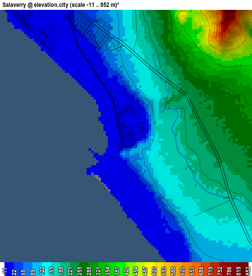
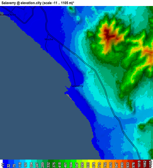
Below is the Elevation map of Salaverry, which displays elevation range with different colors. Scale of the first map is from -11 to 852 m (-36 to 2795 ft) with average elevation of 163.9 meters (=538 ft) [note 1]
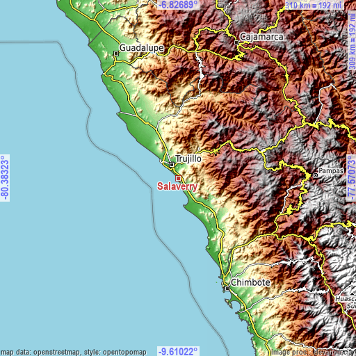
These maps also provides idea of topography and contour of this city, they are displayed at different zoom levels. More info about maps, scale and edge coordinates you can find below images.
| \ | Map #1 | Map #2 | Topo.Map |
| Scale [m] | -11..852 m | -11..1105 m | × |
| Scale [ft] | -36..2795 ft | -36..3625 ft | × |
| Average | 163.9 m = 538 ft | 212 m = 696 ft | × |
| Width | 9.67 km = 6 mi | 19.34 km = 12 mi | 309.5 km = 192.3 mi |
| Height | 9.67 km = 6 mi | 19.34 km = 12 mi | 309.5 km = 192.3 mi |
| ↑Max Latitude | -8.177504° | -8.134003° | -6.82689° |
| Latitude at center | -8.221° | -8.221° | -8.221° |
| ↓Min Latitude | -8.264491° | -8.307978° | -9.61022° |
| ← Min Longitude | -79.020925° | -79.064871° | -80.38323° |
| Longitude center | -78.97698° | -78.97698° | -78.97698° |
| →Max Longitude | -78.933035° | -78.889089° | -77.57073° |
Nearby cities:
Cities around Salaverry sort by population:
• Trujillo elevation 31 m
13.1 km,  333°
333°
• Laredo 97 m
14.7 km,  7°
7°
• Moche 13 m
6.6 km, 327°
• Santiago de Cao 18 m
41 km,  315°
315°
• Virú 75 m
32.9 km,  131°
131°
• Carabamba 3482 m
41.3 km,  73°
73°
• Poroto 644 m
32.8 km,  44°
44°
• Simbal 589 m
32.6 km,  33°
33°
• Huanchaco 15 m
21.7 km,  314°
314°
• La Esperanza 101 m
17.7 km,  335°
335°
• El Porvenir 88 m
15.5 km,  350°
350°
• Buenos Aires 13 m
11.5 km, 322°
Multilingual:
 En español:
Salaverry elevación 8 m.
 En France:
Salaverry élévation 8 m.


Sources and notes:
- [note 1] Map square and city borders are not equal. Map elevation data is calculated only from area inside that square.
- [src 1] Elevation data from geonames database provided with same terms of usage.
- [src 2] The elevation map of Salaverry is generated using elevation data from NASA's 3 arcsec (90m) resolution SRTM data.
- [src 3] Base (background) map © OpenStreetMap contributors tiles are generated by Geofabrik and OpenTopoMap.
Copyright & License:
This Salaverry Elevation Map is licensed under CC BY-SA. You may reuse any part from this page, if you give a proper credit by linking to this URL:
 More info on terms of use page.