El Palmar elevation
El Palmar (Chiriquí), Panama elevation is 16 meters and El Palmar elevation in feet is 52 ft above sea level [src 1]. El Palmar is a populated place (feature code) with elevation that is 156 meters (512 ft) smaller than average city elevation in Panama.
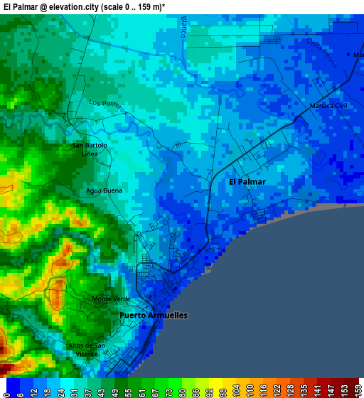
Below is the Elevation map of El Palmar, which displays elevation range with different colors. Scale of the first map is from 0 to 159 m (0 to 522 ft) with average elevation of 34.5 meters (=113 ft) [note 1]
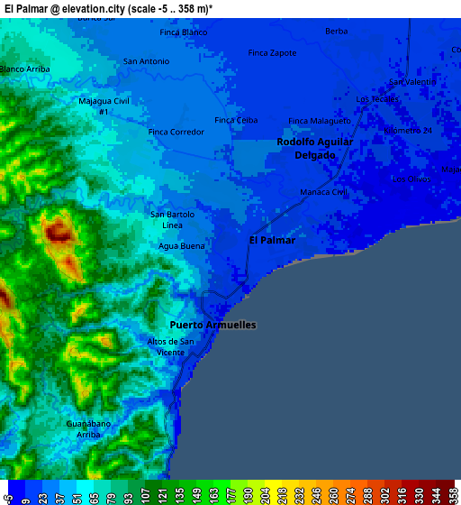
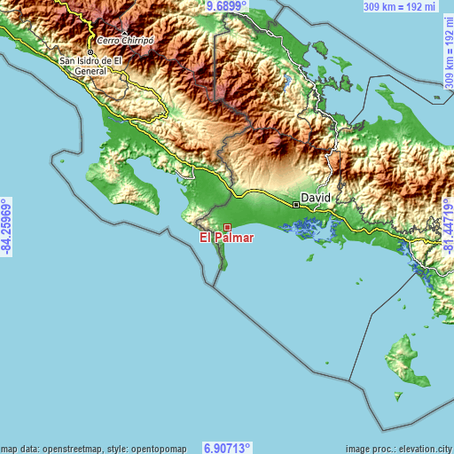
These maps also provides idea of topography and contour of this city, they are displayed at different zoom levels. More info about maps, scale and edge coordinates you can find below images.
| \ | Map #1 | Map #2 | Topo.Map |
| Scale [m] | 0..159 m | -5..358 m | × |
| Scale [ft] | 0..522 ft | -16..1175 ft | × |
| Average | 34.5 m = 113 ft | 55.7 m = 183 ft | × |
| Width | 9.67 km = 6 mi | 19.34 km = 12 mi | 309.4 km = 192.3 mi |
| Height | 9.67 km = 6 mi | 19.34 km = 12 mi | 309.4 km = 192.3 mi |
| ↑Max Latitude | 8.344462° | 8.38794° | 9.6899° |
| Latitude at center | 8.30098° | 8.30098° | 8.30098° |
| ↓Min Latitude | 8.257493° | 8.214001° | 6.90713° |
| ← Min Longitude | -82.897385° | -82.941331° | -84.25969° |
| Longitude center | -82.85344° | -82.85344° | -82.85344° |
| →Max Longitude | -82.809495° | -82.765549° | -81.44719° |
Nearby cities:
Cities around El Palmar sort by population:
• Puerto Armuelles elevation 11 m
2.8 km,  200°
200°
• Divalá 20 m
19.7 km,  51°
51°
• Progreso 24 m
16.3 km,  5°
5°
• La Esperanza 21 m
13.2 km,  30°
30°
• Aserrío de Gariché 63 m
21.3 km,  18°
18°
• San Isidro 126 m
25.7 km, 6°
• Manaca Norte 14 m
6 km, 52°
• Manaca Civil 13 m
4.9 km,  57°
57°
• Celmira 206 m
27.2 km, 12°
• Finca Blanco 24 m
9 km,  345°
345°
• Santo Tomás 21 m
24.4 km,  66°
66°
• Limones 52 m
22.4 km,  183°
183°
Multilingual:
 En español:
El Palmar elevación 16 m.
 En France:
El Palmar élévation 16 m.
 Auf Deutsch:
El Palmar höhe über dem Meeresspiegel ist 16 m.

Sources and notes:
- [note 1] Map square and city borders are not equal. Map elevation data is calculated only from area inside that square.
- [src 1] Elevation data from geonames database provided with same terms of usage.
- [src 2] The elevation map of El Palmar is generated using elevation data from NASA's 3 arcsec (90m) resolution SRTM data.
- [src 3] Base (background) map © OpenStreetMap contributors tiles are generated by Geofabrik and OpenTopoMap.
Copyright & License:
This El Palmar Elevation Map is licensed under CC BY-SA. You may reuse any part from this page, if you give a proper credit by linking to this URL:
 More info on terms of use page.