Aserrío de Gariché elevation
Aserrío de Gariché (Chiriquí), Panama elevation is 63 meters and Aserrío de Gariché elevation in feet is 207 ft above sea level [src 1]. Aserrío de Gariché is a seat of a third-order administrative division (feature code) with elevation that is 109 meters (358 ft) smaller than average city elevation in Panama.
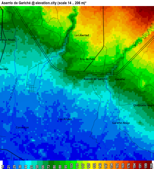
Below is the Elevation map of Aserrío de Gariché, which displays elevation range with different colors. Scale of the first map is from 14 to 206 m (46 to 676 ft) with average elevation of 68 meters (=223 ft) [note 1]
These maps also provides idea of topography and contour of this city, they are displayed at different zoom levels. More info about maps, scale and edge coordinates you can find below images.
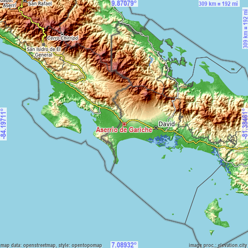
| \ | Map #1 | Topo.Map |
| Scale [m] | 14..206 m | × |
| Scale [ft] | 46..676 ft | × |
| Average | 68 m = 223 ft | × |
| Width | 9.67 km = 6 mi | 309.3 km = 192.2 mi |
| Height | 9.67 km = 6 mi | 309.3 km = 192.2 mi |
| ↑Max Latitude | 8.526032° | 9.87079° |
| Latitude at center | 8.48257° | 8.48257° |
| ↓Min Latitude | 8.439103° | 7.08932° |
| ← Min Longitude | -82.834805° | -84.19711° |
| Longitude center | -82.79086° | -82.79086° |
| →Max Longitude | -82.746915° | -81.38461° |
Nearby cities:
Cities around Aserrío de Gariché sort by population:
• Sioguí Abajo elevation 176 m
13.8 km,  88°
88°
• Divalá 20 m
11.7 km,  133°
133°
• Progreso 24 m
6.6 km,  232°
232°
• Santa Marta 246 m
10.7 km,  70°
70°
• La Esperanza 21 m
8.8 km,  180°
180°
• San Isidro 126 m
6.6 km,  323°
323°
• Gómez 342 m
10.3 km,  31°
31°
• Santo Domingo 211 m
9 km, 71°
• Sioguí Arriba 294 m
13.1 km,  61°
61°
• Paso Canoas Arriba 216 m
9.8 km,  339°
339°
• Celmira 206 m
6.5 km,  350°
350°
• La Estrella 235 m
13.6 km, 74°
Multilingual:
 En español:
Aserrío de Gariché elevación 63 m.
 En France:
Aserrío de Gariché élévation 63 m.
 Auf Deutsch:
Aserrío de Gariché höhe über dem Meeresspiegel ist 63 m.

Sources and notes:
- [note 1] Map square and city borders are not equal. Map elevation data is calculated only from area inside that square.
- [src 1] Elevation data from geonames database provided with same terms of usage.
- [src 2] The elevation map of Aserrío de Gariché is generated using elevation data from NASA's 3 arcsec (90m) resolution SRTM data.
- [src 3] Base (background) map © OpenStreetMap contributors tiles are generated by Geofabrik and OpenTopoMap.
Copyright & License:
This Aserrío de Gariché Elevation Map is licensed under CC BY-SA. You may reuse any part from this page, if you give a proper credit by linking to this URL:
 More info on terms of use page.