Soloy elevation
Soloy (Ngöbe-Buglé), Panama elevation is 142 meters and Soloy elevation in feet is 466 ft above sea level [src 1]. Soloy is a seat of a second-order administrative division (feature code) with elevation that is 30 meters (98 ft) smaller than average city elevation in Panama.
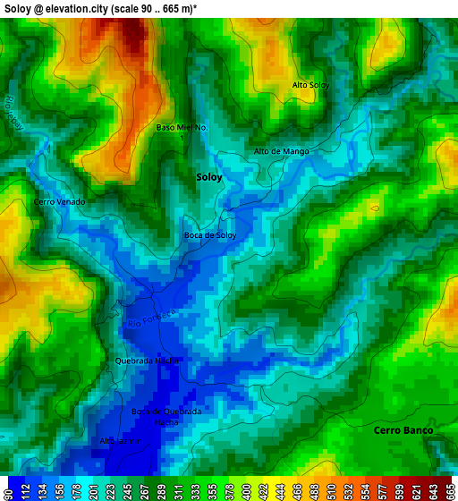
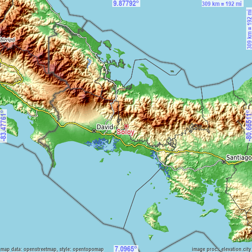
Below is the Elevation map of Soloy, which displays elevation range with different colors. Scale of the first map is from 90 to 665 m (295 to 2182 ft) with average elevation of 279.9 meters (=918 ft) [note 1]
These maps also provides idea of topography and contour of this city, they are displayed at different zoom levels. More info about maps, scale and edge coordinates you can find below images.
| \ | Map #1 | Topo.Map |
| Scale [m] | 90..665 m | × |
| Scale [ft] | 295..2182 ft | × |
| Average | 279.9 m = 918 ft | × |
| Width | 9.67 km = 6 mi | 309.3 km = 192.2 mi |
| Height | 9.67 km = 6 mi | 309.3 km = 192.2 mi |
| ↑Max Latitude | 8.533191° | 9.87792° |
| Latitude at center | 8.48973° | 8.48973° |
| ↓Min Latitude | 8.446264° | 7.0965° |
| ← Min Longitude | -82.115305° | -83.47761° |
| Longitude center | -82.07136° | -82.07136° |
| →Max Longitude | -82.027415° | -80.66511° |
Nearby cities:
Cities around Soloy sort by population:
• San Lorenzo elevation 38 m
20.7 km,  189°
189°
• Horconcitos 35 m
21.7 km,  203°
203°
• Camarón Arriba 432 m
14.6 km,  144°
144°
• Plan de Chorcha 256 m
10.2 km,  252°
252°
• Cerro Banco 326 m
5.7 km,  128°
128°
• Boca del Monte 72 m
15.9 km, 197°
• Boca de Balsa 220 m
6.3 km,  44°
44°
• Hato Corotú 160 m
20.5 km,  147°
147°
• Los Ángeles 349 m
14.6 km,  284°
284°
• Hato Jobo 463 m
23.1 km,  118°
118°
• Cascabel 1188 m
22.1 km,  79°
79°
• Quebrada de Loro 371 m
21.5 km, 132°
Multilingual:
 En español:
Soloy elevación 142 m.
 En France:
Soloy élévation 142 m.


Sources and notes:
- [note 1] Map square and city borders are not equal. Map elevation data is calculated only from area inside that square.
- [src 1] Elevation data from geonames database provided with same terms of usage.
- [src 2] The elevation map of Soloy is generated using elevation data from NASA's 3 arcsec (90m) resolution SRTM data.
- [src 3] Base (background) map © OpenStreetMap contributors tiles are generated by Geofabrik and OpenTopoMap.
Copyright & License:
This Soloy Elevation Map is licensed under CC BY-SA. You may reuse any part from this page, if you give a proper credit by linking to this URL:
 More info on terms of use page.