Los Ángeles elevation
Los Ángeles (Chiriquí), Panama elevation is 349 meters and Los Ángeles elevation in feet is 1145 ft above sea level [src 1]. Los Ángeles is a seat of a third-order administrative division (feature code) with elevation that is 177 meters (581 ft) bigger than average city elevation in Panama.
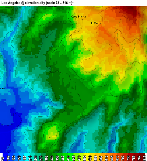
Below is the Elevation map of Los Ángeles, which displays elevation range with different colors. Scale of the first map is from 73 to 816 m (240 to 2677 ft) with average elevation of 347.1 meters (=1139 ft) [note 1]
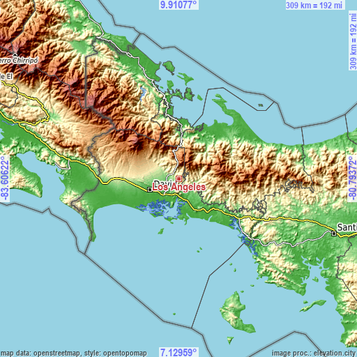
These maps also provides idea of topography and contour of this city, they are displayed at different zoom levels. More info about maps, scale and edge coordinates you can find below images.
| \ | Map #1 | Topo.Map |
| Scale [m] | 73..816 m | × |
| Scale [ft] | 240..2677 ft | × |
| Average | 347.1 m = 1139 ft | × |
| Width | 9.66 km = 6 mi | 309.2 km = 192.1 mi |
| Height | 9.66 km = 6 mi | 309.3 km = 192.2 mi |
| ↑Max Latitude | 8.566168° | 9.91077° |
| Latitude at center | 8.52271° | 8.52271° |
| ↓Min Latitude | 8.479248° | 7.12959° |
| ← Min Longitude | -82.243915° | -83.60622° |
| Longitude center | -82.19997° | -82.19997° |
| →Max Longitude | -82.156025° | -80.79372° |
Nearby cities:
Cities around Los Ángeles sort by population:
• Gualaca elevation 121 m
11 km,  274°
274°
• Chiriquí 36 m
19.6 km,  222°
222°
• Rincón 63 m
10.9 km,  233°
233°
• Plan de Chorcha 256 m
8.1 km,  146°
146°
• Cerro Banco 326 m
19.9 km,  111°
111°
• Cochea Abajo 127 m
17.6 km,  263°
263°
• Boca del Monte 72 m
21.1 km, 153°
• Boca de Balsa 220 m
18.6 km,  87°
87°
• Bijagual 122 m
14.7 km, 266°
• Dos Ríos Abajo 155 m
20.6 km, 271°
• Valle de La Mina 807 m
16.1 km,  347°
347°
• Soloy 142 m
14.6 km,  104°
104°
Multilingual:
 En español:
Los Ángeles elevación 349 m.
 En France:
Los Ángeles élévation 349 m.
 Auf Deutsch:
Los Ángeles höhe über dem Meeresspiegel ist 349 m.

Sources and notes:
- [note 1] Map square and city borders are not equal. Map elevation data is calculated only from area inside that square.
- [src 1] Elevation data from geonames database provided with same terms of usage.
- [src 2] The elevation map of Los Ángeles is generated using elevation data from NASA's 3 arcsec (90m) resolution SRTM data.
- [src 3] Base (background) map © OpenStreetMap contributors tiles are generated by Geofabrik and OpenTopoMap.
Copyright & License:
This Los Ángeles Elevation Map is licensed under CC BY-SA. You may reuse any part from this page, if you give a proper credit by linking to this URL:
 More info on terms of use page.