La Yeguada elevation
La Yeguada (Veraguas), Panama elevation is 578 meters and La Yeguada elevation in feet is 1896 ft above sea level [src 1]. La Yeguada is a seat of a third-order administrative division (feature code) with elevation that is 406 meters (1332 ft) bigger than average city elevation in Panama.
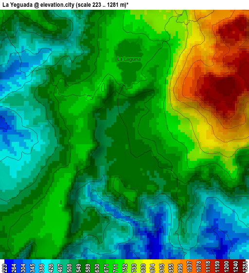
Below is the Elevation map of La Yeguada, which displays elevation range with different colors. Scale of the first map is from 223 to 1281 m (732 to 4203 ft) with average elevation of 617.1 meters (=2025 ft) [note 1]
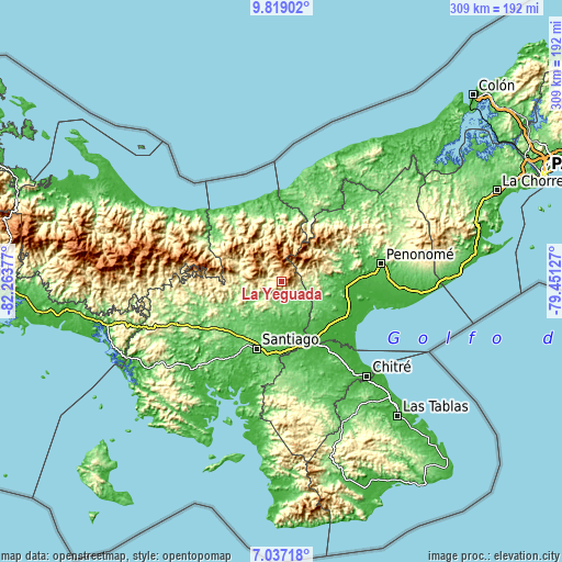
These maps also provides idea of topography and contour of this city, they are displayed at different zoom levels. More info about maps, scale and edge coordinates you can find below images.
| \ | Map #1 | Topo.Map |
| Scale [m] | 223..1281 m | × |
| Scale [ft] | 732..4203 ft | × |
| Average | 617.1 m = 2025 ft | × |
| Width | 9.67 km = 6 mi | 309.3 km = 192.2 mi |
| Height | 9.67 km = 6 mi | 309.3 km = 192.2 mi |
| ↑Max Latitude | 8.474068° | 9.81902° |
| Latitude at center | 8.4306° | 8.4306° |
| ↓Min Latitude | 8.387127° | 7.03718° |
| ← Min Longitude | -80.901465° | -82.26377° |
| Longitude center | -80.85752° | -80.85752° |
| →Max Longitude | -80.813575° | -79.45127° |
Nearby cities:
Cities around La Yeguada sort by population:
• Calobre elevation 125 m
12.6 km,  171°
171°
• Las Huacas del Quije 438 m
12.4 km,  70°
70°
• El Peñón 178 m
15.8 km,  235°
235°
• El Copé 338 m
19.6 km,  87°
87°
• El Potrero 181 m
9.2 km,  130°
130°
• Monjarás 185 m
6.9 km,  188°
188°
• Piedras Gordas 544 m
12 km,  330°
330°
• San José 862 m
7 km,  54°
54°
• Barnizal 367 m
9.2 km,  108°
108°
• La Laguna 142 m
17.4 km, 125°
• El Coclá 250 m
14 km,  209°
209°
• Gatú 667 m
15.7 km,  319°
319°
Multilingual:
 En español:
La Yeguada elevación 578 m.
 En France:
La Yeguada élévation 578 m.
 Auf Deutsch:
La Yeguada höhe über dem Meeresspiegel ist 578 m.

Sources and notes:
- [note 1] Map square and city borders are not equal. Map elevation data is calculated only from area inside that square.
- [src 1] Elevation data from geonames database provided with same terms of usage.
- [src 2] The elevation map of La Yeguada is generated using elevation data from NASA's 3 arcsec (90m) resolution SRTM data.
- [src 3] Base (background) map © OpenStreetMap contributors tiles are generated by Geofabrik and OpenTopoMap.
Copyright & License:
This La Yeguada Elevation Map is licensed under CC BY-SA. You may reuse any part from this page, if you give a proper credit by linking to this URL:
 More info on terms of use page.