El Copé elevation
El Copé (Coclé), Panama elevation is 338 meters and El Copé elevation in feet is 1109 ft above sea level [src 1]. El Copé is a seat of a third-order administrative division (feature code) with elevation that is 166 meters (545 ft) bigger than average city elevation in Panama.
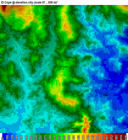
Below is the Elevation map of El Copé, which displays elevation range with different colors. Scale of the first map is from 81 to 636 m (266 to 2087 ft) with average elevation of 231 meters (=758 ft) [note 1]
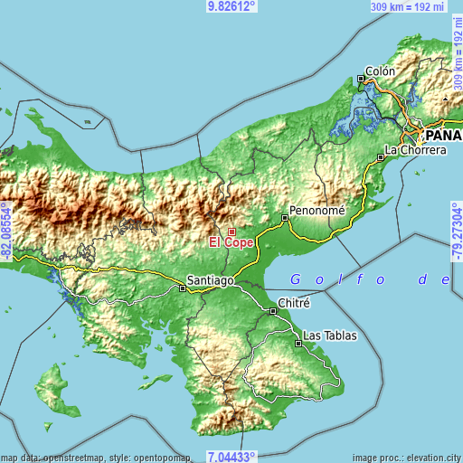
These maps also provides idea of topography and contour of this city, they are displayed at different zoom levels. More info about maps, scale and edge coordinates you can find below images.
| \ | Map #1 | Topo.Map |
| Scale [m] | 81..636 m | × |
| Scale [ft] | 266..2087 ft | × |
| Average | 231 m = 758 ft | × |
| Width | 9.67 km = 6 mi | 309.3 km = 192.2 mi |
| Height | 9.67 km = 6 mi | 309.3 km = 192.2 mi |
| ↑Max Latitude | 8.481197° | 9.82612° |
| Latitude at center | 8.43773° | 8.43773° |
| ↓Min Latitude | 8.394258° | 7.04433° |
| ← Min Longitude | -80.723235° | -82.08554° |
| Longitude center | -80.67929° | -80.67929° |
| →Max Longitude | -80.635345° | -79.27304° |
Nearby cities:
Cities around El Copé sort by population:
• El Cortezo elevation 59 m
14.4 km,  135°
135°
• Las Huacas del Quije 438 m
8.5 km,  292°
292°
• Olá 129 m
3.8 km,  125°
125°
• Toza 80 m
11.1 km,  157°
157°
• Nuestro Amo 49 m
9.9 km,  85°
85°
• Guzman 138 m
13.9 km,  48°
48°
• El Potrero 181 m
14.3 km,  241°
241°
• Las Sabanas 566 m
16 km,  359°
359°
• San José 862 m
14.2 km,  283°
283°
• Barnizal 367 m
11.4 km,  251°
251°
• La Laguna 142 m
12.3 km,  206°
206°
• Barranco Colorado 88 m
7.2 km, 138°
Multilingual:
 En español:
El Copé elevación 338 m.
 En France:
El Copé élévation 338 m.


Sources and notes:
- [note 1] Map square and city borders are not equal. Map elevation data is calculated only from area inside that square.
- [src 1] Elevation data from geonames database provided with same terms of usage.
- [src 2] The elevation map of El Copé is generated using elevation data from NASA's 3 arcsec (90m) resolution SRTM data.
- [src 3] Base (background) map © OpenStreetMap contributors tiles are generated by Geofabrik and OpenTopoMap.
Copyright & License:
This El Copé Elevation Map is licensed under CC BY-SA. You may reuse any part from this page, if you give a proper credit by linking to this URL:
 More info on terms of use page.