Buabidi elevation
Buabidi (Ngöbe-Buglé), Panama elevation is 1162 meters and Buabidi elevation in feet is 3812 ft above sea level [src 1]. Buabidi is a seat of a first-order administrative division (feature code) with elevation that is 990 meters (3248 ft) bigger than average city elevation in Panama.
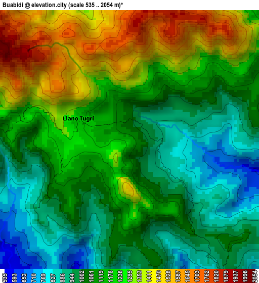
Below is the Elevation map of Buabidi, which displays elevation range with different colors. Scale of the first map is from 535 to 2054 m (1755 to 6739 ft) with average elevation of 1145.4 meters (=3758 ft) [note 1]
These maps also provides idea of topography and contour of this city, they are displayed at different zoom levels. More info about maps, scale and edge coordinates you can find below images.
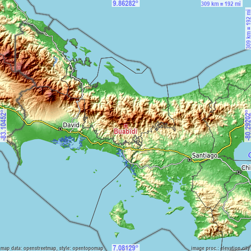
| \ | Map #1 | Topo.Map |
| Scale [m] | 535..2054 m | × |
| Scale [ft] | 1755..6739 ft | × |
| Average | 1145.4 m = 3758 ft | × |
| Width | 9.67 km = 6 mi | 309.3 km = 192.2 mi |
| Height | 9.67 km = 6 mi | 309.3 km = 192.2 mi |
| ↑Max Latitude | 8.518033° | 9.86282° |
| Latitude at center | 8.47457° | 8.47457° |
| ↓Min Latitude | 8.431102° | 7.08129° |
| ← Min Longitude | -81.742215° | -83.10452° |
| Longitude center | -81.69827° | -81.69827° |
| →Max Longitude | -81.654325° | -80.29202° |
Nearby cities:
Cities around Buabidi sort by population:
• Quebrada Canoa elevation 669 m
10.4 km,  243°
243°
• Chichica 469 m
13.4 km,  164°
164°
• Hato Chami 954 m
8.8 km,  246°
246°
• Cerro Caña 429 m
16.7 km,  144°
144°
• Llano Ñopo 342 m
10.7 km,  124°
124°
• Sitio Prado 272 m
17.2 km,  131°
131°
• Cerro Plata 845 m
16.8 km,  88°
88°
• Hato Culantro 734 m
17.5 km,  267°
267°
• Piedra Roja 788 m
11.9 km,  333°
333°
• Maraca 503 m
11.7 km,  195°
195°
• Mirones 996 m
9.7 km,  341°
341°
• Peña Blanca 839 m
2.6 km, 123°
Multilingual:
 En español:
Buabidi, Llano Tugrí, Buäbti elevación 1162 m.
 En France:
Buabidi élévation 1162 m.
 Auf Deutsch:
Buabidi höhe über dem Meeresspiegel ist 1162 m.

Sources and notes:
- [note 1] Map square and city borders are not equal. Map elevation data is calculated only from area inside that square.
- [src 1] Elevation data from geonames database provided with same terms of usage.
- [src 2] The elevation map of Buabidi is generated using elevation data from NASA's 3 arcsec (90m) resolution SRTM data.
- [src 3] Base (background) map © OpenStreetMap contributors tiles are generated by Geofabrik and OpenTopoMap.
Copyright & License:
This Buabidi Elevation Map is licensed under CC BY-SA. You may reuse any part from this page, if you give a proper credit by linking to this URL:
 More info on terms of use page.