Maraca elevation
Maraca (Ngöbe-Buglé), Panama elevation is 503 meters and Maraca elevation in feet is 1650 ft above sea level [src 1]. Maraca is a seat of a third-order administrative division (feature code) with elevation that is 331 meters (1086 ft) bigger than average city elevation in Panama.
Below is the Elevation map of Maraca, which displays elevation range with different colors. Scale of the first map is from 158 to 1125 m (518 to 3691 ft) with average elevation of 504.7 meters (=1656 ft) [note 1]
These maps also provides idea of topography and contour of this city, they are displayed at different zoom levels. More info about maps, scale and edge coordinates you can find below images.
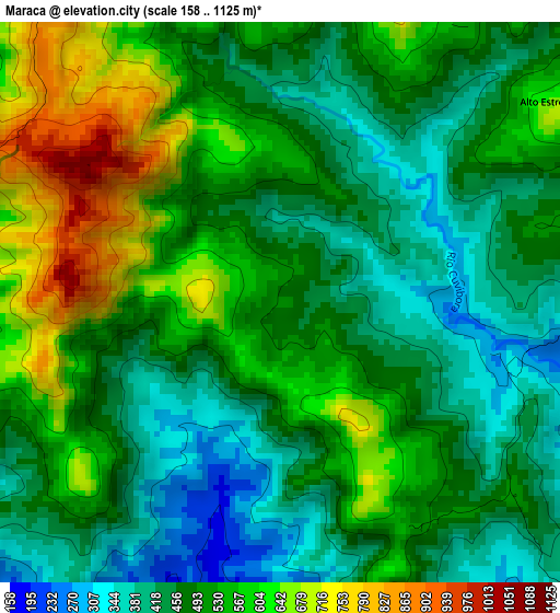
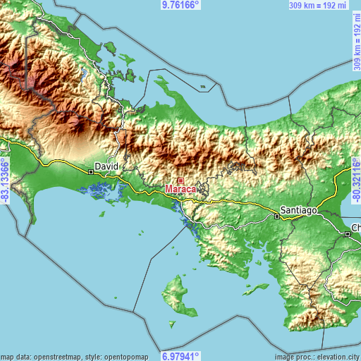
| \ | Map #1 | Topo.Map |
| Scale [m] | 158..1125 m | × |
| Scale [ft] | 518..3691 ft | × |
| Average | 504.7 m = 1656 ft | × |
| Width | 9.67 km = 6 mi | 309.4 km = 192.3 mi |
| Height | 9.67 km = 6 mi | 309.4 km = 192.3 mi |
| ↑Max Latitude | 8.416494° | 9.76166° |
| Latitude at center | 8.37302° | 8.37302° |
| ↓Min Latitude | 8.329541° | 6.97941° |
| ← Min Longitude | -81.771355° | -83.13366° |
| Longitude center | -81.72741° | -81.72741° |
| →Max Longitude | -81.683465° | -80.32116° |
Nearby cities:
Cities around Maraca sort by population:
• Quebrada Canoa elevation 669 m
9.1 km,  317°
317°
• Chichica 469 m
7 km,  103°
103°
• Hato Chami 954 m
9.2 km,  327°
327°
• Lajero Arriba 233 m
10.3 km,  207°
207°
• Oma 436 m
8.6 km,  252°
252°
• Llano Ñopo 342 m
13.1 km,  66°
66°
• Cerro Iglesias 369 m
12.5 km,  218°
218°
• Buabidi 1162 m
11.7 km,  15°
15°
• Peña Blanca 839 m
11.2 km,  28°
28°
• Alto Caballero 446 m
11 km,  147°
147°
• Potrero de Caña 456 m
9.4 km,  160°
160°
• Cabecera de Cerro Puerco 331 m
7 km, 210°
Multilingual:
 En español:
Maraca elevación 503 m.
 En France:
Maraca élévation 503 m.


Sources and notes:
- [note 1] Map square and city borders are not equal. Map elevation data is calculated only from area inside that square.
- [src 1] Elevation data from geonames database provided with same terms of usage.
- [src 2] The elevation map of Maraca is generated using elevation data from NASA's 3 arcsec (90m) resolution SRTM data.
- [src 3] Base (background) map © OpenStreetMap contributors tiles are generated by Geofabrik and OpenTopoMap.
Copyright & License:
This Maraca Elevation Map is licensed under CC BY-SA. You may reuse any part from this page, if you give a proper credit by linking to this URL:
 More info on terms of use page.