Narganá elevation
Narganá (Guna Yala), Panama elevation is 4 meters and Narganá elevation in feet is 13 ft above sea level [src 1]. Narganá is a populated place (feature code) with elevation that is 168 meters (551 ft) smaller than average city elevation in Panama.
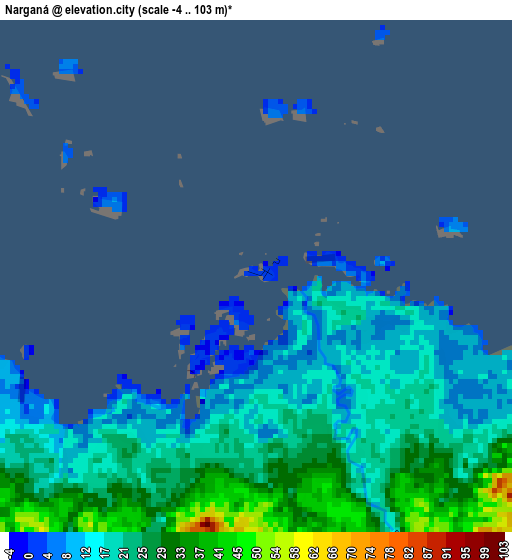
Below is the Elevation map of Narganá, which displays elevation range with different colors. Scale of the first map is from -4 to 103 m (-13 to 338 ft) with average elevation of 21.1 meters (=69 ft) [note 1]
These maps also provides idea of topography and contour of this city, they are displayed at different zoom levels. More info about maps, scale and edge coordinates you can find below images.
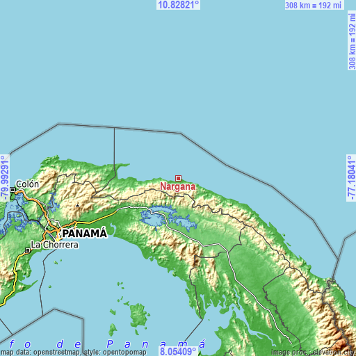
| \ | Map #1 | Topo.Map |
| Scale [m] | -4..103 m | × |
| Scale [ft] | -13..338 ft | × |
| Average | 21.1 m = 69 ft | × |
| Width | 9.64 km = 6 mi | 308.5 km = 191.7 mi |
| Height | 9.64 km = 6 mi | 308.5 km = 191.7 mi |
| ↑Max Latitude | 9.487287° | 10.82821° |
| Latitude at center | 9.44394° | 9.44394° |
| ↓Min Latitude | 9.400588° | 8.05409° |
| ← Min Longitude | -78.630605° | -79.99291° |
| Longitude center | -78.58666° | -78.58666° |
| →Max Longitude | -78.542715° | -77.18041° |
Nearby cities:
Cities around Narganá sort by population:
• Chepo elevation 19 m
64.1 km,  241°
241°
• El Progreso 144 m
61.4 km,  251°
251°
• Las Margaritas 21 m
62.1 km, 242°
• Playón Chico 5 m
41.5 km,  110°
110°
• Ailigandí 3 m
65.8 km, 111°
• Tortí 171 m
61.4 km,  161°
161°
• San Ignacio de Tupile 4 m
50.7 km, 109°
• Tubualá 3 m
49.6 km,  279°
279°
• Cartí Sugdup 3 m
40.9 km,  273°
273°
• Cañita 27 m
41.9 km,  233°
233°
• Pásiga 45 m
66.6 km,  212°
212°
• El Porvenir 2 m
41.9 km,  286°
286°
Multilingual:
 En español:
Narganá elevación 4 m.
 En France:
Narganá élévation 4 m.


Sources and notes:
- [note 1] Map square and city borders are not equal. Map elevation data is calculated only from area inside that square.
- [src 1] Elevation data from geonames database provided with same terms of usage.
- [src 2] The elevation map of Narganá is generated using elevation data from NASA's 3 arcsec (90m) resolution SRTM data.
- [src 3] Base (background) map © OpenStreetMap contributors tiles are generated by Geofabrik and OpenTopoMap.
Copyright & License:
This Narganá Elevation Map is licensed under CC BY-SA. You may reuse any part from this page, if you give a proper credit by linking to this URL:
 More info on terms of use page.