Paraíso elevation
Paraíso (Chiriquí), Panama elevation is 806 meters and Paraíso elevation in feet is 2644 ft above sea level [src 1]. Paraíso is a seat of a third-order administrative division (feature code) with elevation that is 634 meters (2080 ft) bigger than average city elevation in Panama.
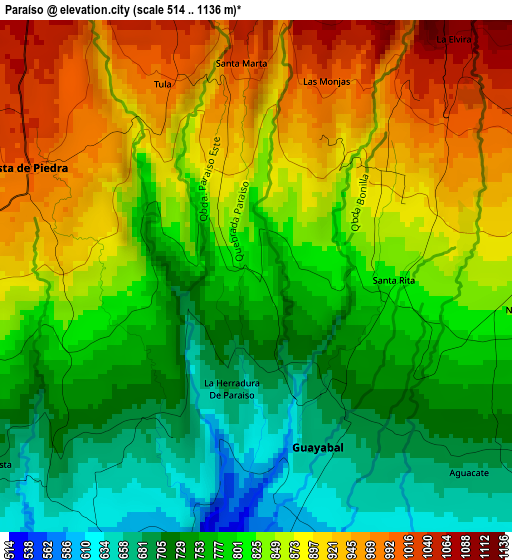
Below is the Elevation map of Paraíso, which displays elevation range with different colors. Scale of the first map is from 514 to 1136 m (1686 to 3727 ft) with average elevation of 822 meters (=2697 ft) [note 1]
These maps also provides idea of topography and contour of this city, they are displayed at different zoom levels. More info about maps, scale and edge coordinates you can find below images.
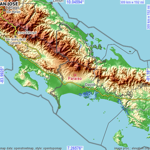
| \ | Map #1 | Topo.Map |
| Scale [m] | 514..1136 m | × |
| Scale [ft] | 1686..3727 ft | × |
| Average | 822 m = 2697 ft | × |
| Width | 9.66 km = 6 mi | 309.1 km = 192.1 mi |
| Height | 9.66 km = 6 mi | 309.2 km = 192.1 mi |
| ↑Max Latitude | 8.701862° | 10.04594° |
| Latitude at center | 8.65842° | 8.65842° |
| ↓Min Latitude | 8.614973° | 7.26576° |
| ← Min Longitude | -82.630195° | -83.9925° |
| Longitude center | -82.58625° | -82.58625° |
| →Max Longitude | -82.542305° | -81.18° |
Nearby cities:
Cities around Paraíso sort by population:
• Volcán elevation 1394 m
14 km,  335°
335°
• Sortova 375 m
14.4 km,  210°
210°
• Potrerillos Abajo 633 m
11.3 km,  100°
100°
• Palmira 1084 m
16.3 km,  59°
59°
• Bugabita Arriba 222 m
16.2 km,  199°
199°
• Potrerillos Arriba 904 m
10.9 km,  73°
73°
• Cordillera 1083 m
5.7 km, 340°
• Rovira Arriba 665 m
9.8 km, 103°
• Guayabal 619 m
4.1 km,  169°
169°
• Santa Rosa 516 m
12.7 km,  238°
238°
• Guabal 444 m
10.8 km,  149°
149°
• Bongo Arriba 478 m
8.7 km, 207°
Multilingual:
 En español:
Paraíso elevación 806 m.
 En France:
Paraíso élévation 806 m.


Sources and notes:
- [note 1] Map square and city borders are not equal. Map elevation data is calculated only from area inside that square.
- [src 1] Elevation data from geonames database provided with same terms of usage.
- [src 2] The elevation map of Paraíso is generated using elevation data from NASA's 3 arcsec (90m) resolution SRTM data.
- [src 3] Base (background) map © OpenStreetMap contributors tiles are generated by Geofabrik and OpenTopoMap.
Copyright & License:
This Paraíso Elevation Map is licensed under CC BY-SA. You may reuse any part from this page, if you give a proper credit by linking to this URL:
 More info on terms of use page.