Potrerillos Abajo elevation
Potrerillos Abajo (Chiriquí), Panama elevation is 633 meters and Potrerillos Abajo elevation in feet is 2077 ft above sea level [src 1]. Potrerillos Abajo is a seat of a third-order administrative division (feature code) with elevation that is 461 meters (1512 ft) bigger than average city elevation in Panama.
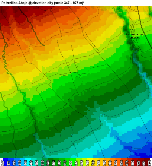
Below is the Elevation map of Potrerillos Abajo, which displays elevation range with different colors. Scale of the first map is from 347 to 975 m (1138 to 3199 ft) with average elevation of 639.8 meters (=2099 ft) [note 1]
These maps also provides idea of topography and contour of this city, they are displayed at different zoom levels. More info about maps, scale and edge coordinates you can find below images.
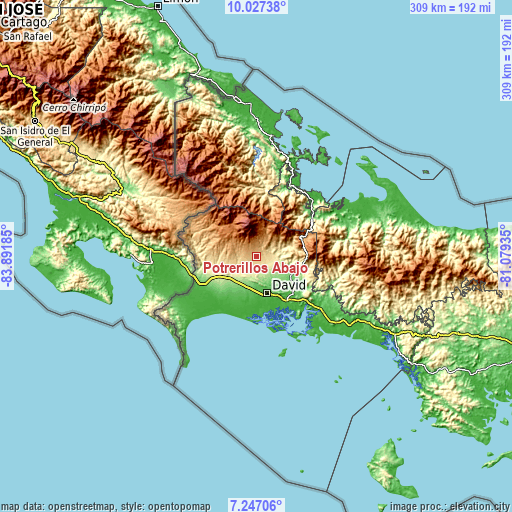
| \ | Map #1 | Topo.Map |
| Scale [m] | 347..975 m | × |
| Scale [ft] | 1138..3199 ft | × |
| Average | 639.8 m = 2099 ft | × |
| Width | 9.66 km = 6 mi | 309.1 km = 192.1 mi |
| Height | 9.66 km = 6 mi | 309.2 km = 192.1 mi |
| ↑Max Latitude | 8.683224° | 10.02738° |
| Latitude at center | 8.63978° | 8.63978° |
| ↓Min Latitude | 8.596331° | 7.24706° |
| ← Min Longitude | -82.529545° | -83.89185° |
| Longitude center | -82.4856° | -82.4856° |
| →Max Longitude | -82.441655° | -81.07935° |
Nearby cities:
Cities around Potrerillos Abajo sort by population:
• Alto Boquete elevation 1031 m
12.1 km,  29°
29°
• Dolega District 247 m
11.3 km,  135°
135°
• Palmira 1084 m
10.9 km,  15°
15°
• Potrerillos Arriba 904 m
5.1 km,  353°
353°
• Palmira Centro 1095 m
11.7 km, 18°
• Tinajas 273 m
10.1 km,  163°
163°
• Guaca Arriba 269 m
11.4 km,  183°
183°
• Rovira Arriba 665 m
1.6 km,  263°
263°
• Caldera 370 m
11.6 km,  84°
84°
• Paraíso 806 m
11.3 km,  280°
280°
• Guayabal 619 m
10.5 km, 259°
• Guabal 444 m
9.2 km,  218°
218°
Multilingual:
 En español:
Potrerillos Abajo elevación 633 m.
 En France:
Potrerillos Abajo élévation 633 m.
 Auf Deutsch:
Potrerillos Abajo höhe über dem Meeresspiegel ist 633 m.

Sources and notes:
- [note 1] Map square and city borders are not equal. Map elevation data is calculated only from area inside that square.
- [src 1] Elevation data from geonames database provided with same terms of usage.
- [src 2] The elevation map of Potrerillos Abajo is generated using elevation data from NASA's 3 arcsec (90m) resolution SRTM data.
- [src 3] Base (background) map © OpenStreetMap contributors tiles are generated by Geofabrik and OpenTopoMap.
Copyright & License:
This Potrerillos Abajo Elevation Map is licensed under CC BY-SA. You may reuse any part from this page, if you give a proper credit by linking to this URL:
 More info on terms of use page.