Parita elevation
Parita (Herrera), Panama elevation is 32 meters and Parita elevation in feet is 105 ft above sea level [src 1]. Parita is a seat of a second-order administrative division (feature code) with elevation that is 140 meters (459 ft) smaller than average city elevation in Panama.
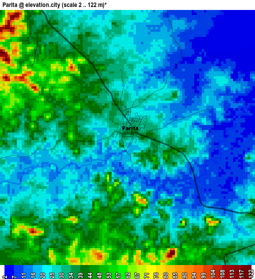
Below is the Elevation map of Parita, which displays elevation range with different colors. Scale of the first map is from 2 to 122 m (7 to 400 ft) with average elevation of 30 meters (=98 ft) [note 1]
These maps also provides idea of topography and contour of this city, they are displayed at different zoom levels. More info about maps, scale and edge coordinates you can find below images.
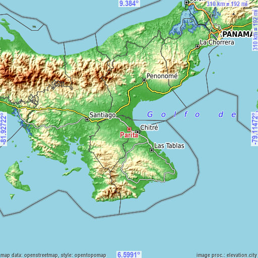
| \ | Map #1 | Topo.Map |
| Scale [m] | 2..122 m | × |
| Scale [ft] | 7..400 ft | × |
| Average | 30 m = 98 ft | × |
| Width | 9.68 km = 6 mi | 309.7 km = 192.4 mi |
| Height | 9.68 km = 6 mi | 309.7 km = 192.4 mi |
| ↑Max Latitude | 8.037446° | 9.384° |
| Latitude at center | 7.99393° | 7.99393° |
| ↓Min Latitude | 7.950409° | 6.5991° |
| ← Min Longitude | -80.564915° | -81.92722° |
| Longitude center | -80.52097° | -80.52097° |
| →Max Longitude | -80.477025° | -79.11472° |
Nearby cities:
Cities around Parita sort by population:
• San Juan Bautista elevation 19 m
12.5 km,  107°
107°
• Monagrillo 29 m
9.3 km,  98°
98°
• Llano Bonito 16 m
11.7 km, 99°
• Chitré 34 m
10.7 km, 110°
• La Arena 40 m
6.8 km,  115°
115°
• Boca de Parita 5 m
7.6 km,  78°
78°
• París 25 m
7.3 km,  329°
329°
• Los Olivos 33 m
9.4 km,  157°
157°
• Portobelillo 59 m
8.6 km,  287°
287°
• Los Castillos 52 m
10.8 km,  265°
265°
• El Pájaro 47 m
7.8 km,  223°
223°
• El Barrero 42 m
6.8 km,  173°
173°
Multilingual:
 En español:
Parita elevación 32 m.
 En France:
Parita élévation 32 m.


Sources and notes:
- [note 1] Map square and city borders are not equal. Map elevation data is calculated only from area inside that square.
- [src 1] Elevation data from geonames database provided with same terms of usage.
- [src 2] The elevation map of Parita is generated using elevation data from NASA's 3 arcsec (90m) resolution SRTM data.
- [src 3] Base (background) map © OpenStreetMap contributors tiles are generated by Geofabrik and OpenTopoMap.
Copyright & License:
This Parita Elevation Map is licensed under CC BY-SA. You may reuse any part from this page, if you give a proper credit by linking to this URL:
 More info on terms of use page.