Portobelillo elevation
Portobelillo (Herrera), Panama elevation is 59 meters and Portobelillo elevation in feet is 194 ft above sea level [src 1]. Portobelillo is a seat of a third-order administrative division (feature code) with elevation that is 113 meters (371 ft) smaller than average city elevation in Panama.
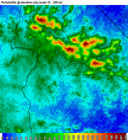
Below is the Elevation map of Portobelillo, which displays elevation range with different colors. Scale of the first map is from 10 to 209 m (33 to 686 ft) with average elevation of 56.2 meters (=184 ft) [note 1]
These maps also provides idea of topography and contour of this city, they are displayed at different zoom levels. More info about maps, scale and edge coordinates you can find below images.
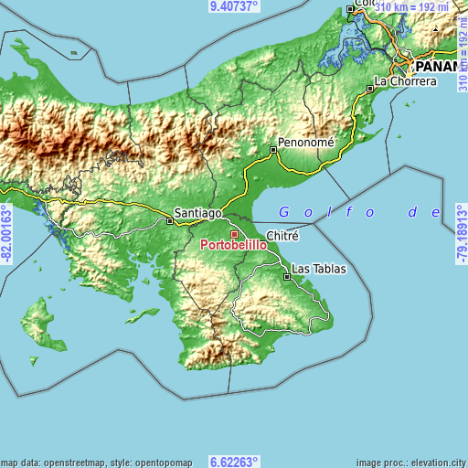
| \ | Map #1 | Topo.Map |
| Scale [m] | 10..209 m | × |
| Scale [ft] | 33..686 ft | × |
| Average | 56.2 m = 184 ft | × |
| Width | 9.68 km = 6 mi | 309.6 km = 192.4 mi |
| Height | 9.68 km = 6 mi | 309.7 km = 192.4 mi |
| ↑Max Latitude | 8.060893° | 9.40737° |
| Latitude at center | 8.01738° | 8.01738° |
| ↓Min Latitude | 7.973862° | 6.62263° |
| ← Min Longitude | -80.639325° | -82.00163° |
| Longitude center | -80.59538° | -80.59538° |
| →Max Longitude | -80.551435° | -79.18913° |
Nearby cities:
Cities around Portobelillo sort by population:
• Parita elevation 32 m
8.6 km,  107°
107°
• Pesé 85 m
12.3 km,  189°
189°
• Santa María 14 m
13 km,  323°
323°
• El Rincón 12 m
11.6 km,  348°
348°
• París 25 m
5.9 km,  50°
50°
• Potuga 33 m
5.9 km,  329°
329°
• El Pedregoso 71 m
10.2 km,  207°
207°
• Cabuya 50 m
4.3 km,  290°
290°
• Los Castillos 52 m
4.4 km,  216°
216°
• Llano de La Cruz 36 m
8.9 km, 215°
• El Barrero 42 m
13 km,  136°
136°
• El Pájaro 47 m
8.7 km,  161°
161°
Multilingual:
 En español:
Portobelillo elevación 59 m.
 En France:
Portobelillo élévation 59 m.
 Auf Deutsch:
Portobelillo höhe über dem Meeresspiegel ist 59 m.

Sources and notes:
- [note 1] Map square and city borders are not equal. Map elevation data is calculated only from area inside that square.
- [src 1] Elevation data from geonames database provided with same terms of usage.
- [src 2] The elevation map of Portobelillo is generated using elevation data from NASA's 3 arcsec (90m) resolution SRTM data.
- [src 3] Base (background) map © OpenStreetMap contributors tiles are generated by Geofabrik and OpenTopoMap.
Copyright & License:
This Portobelillo Elevation Map is licensed under CC BY-SA. You may reuse any part from this page, if you give a proper credit by linking to this URL:
 More info on terms of use page.