Vista Hermosa elevation
Vista Hermosa (Coclé), Panama elevation is 87 meters and Vista Hermosa elevation in feet is 285 ft above sea level [src 1]. Vista Hermosa is a populated place (feature code) with elevation that is 85 meters (279 ft) smaller than average city elevation in Panama.
Below is the Elevation map of Vista Hermosa, which displays elevation range with different colors. Scale of the first map is from 30 to 435 m (98 to 1427 ft) with average elevation of 92.8 meters (=304 ft) [note 1]
These maps also provides idea of topography and contour of this city, they are displayed at different zoom levels. More info about maps, scale and edge coordinates you can find below images.
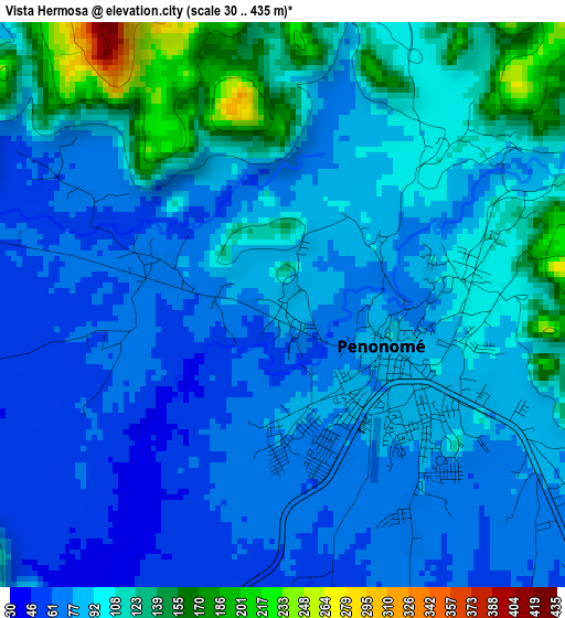
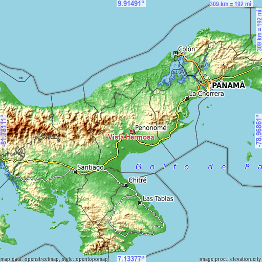
| \ | Map #1 | Topo.Map |
| Scale [m] | 30..435 m | × |
| Scale [ft] | 98..1427 ft | × |
| Average | 92.8 m = 304 ft | × |
| Width | 9.66 km = 6 mi | 309.2 km = 192.1 mi |
| Height | 9.66 km = 6 mi | 309.3 km = 192.2 mi |
| ↑Max Latitude | 8.570327° | 9.91491° |
| Latitude at center | 8.52687° | 8.52687° |
| ↓Min Latitude | 8.483408° | 7.13377° |
| ← Min Longitude | -80.418805° | -81.78111° |
| Longitude center | -80.37486° | -80.37486° |
| →Max Longitude | -80.330915° | -78.96861° |
Nearby cities:
Cities around Vista Hermosa sort by population:
• Penonomé elevation 90 m
2.1 km,  114°
114°
• Chigoré 92 m
2.6 km,  81°
81°
• Juan Díaz 63 m
12.4 km,  125°
125°
• La Pintada 69 m
10.5 km,  314°
314°
• Llano Marín 56 m
7.8 km,  135°
135°
• Churuquita Grande 175 m
13.6 km,  56°
56°
• Coclé 30 m
9.9 km,  217°
217°
• Churuquita Chiquita 175 m
12.6 km, 64°
• Aguas Blancas 77 m
7.4 km, 110°
• Cañaveral 39 m
6.1 km,  259°
259°
• Las Minas 209 m
12.9 km,  350°
350°
• Llano Grande 128 m
14.2 km,  330°
330°
Multilingual:
 En español:
Vista Hermosa elevación 87 m.
 En France:
Vista Hermosa élévation 87 m.
 Auf Deutsch:
Vista Hermosa höhe über dem Meeresspiegel ist 87 m.

Sources and notes:
- [note 1] Map square and city borders are not equal. Map elevation data is calculated only from area inside that square.
- [src 1] Elevation data from geonames database provided with same terms of usage.
- [src 2] The elevation map of Vista Hermosa is generated using elevation data from NASA's 3 arcsec (90m) resolution SRTM data.
- [src 3] Base (background) map © OpenStreetMap contributors tiles are generated by Geofabrik and OpenTopoMap.
Copyright & License:
This Vista Hermosa Elevation Map is licensed under CC BY-SA. You may reuse any part from this page, if you give a proper credit by linking to this URL:
 More info on terms of use page.