Churuquita Grande elevation
Churuquita Grande (Coclé), Panama elevation is 175 meters and Churuquita Grande elevation in feet is 574 ft above sea level [src 1]. Churuquita Grande is a populated place (feature code) with elevation that is 3 meters (10 ft) bigger than average city elevation in Panama.
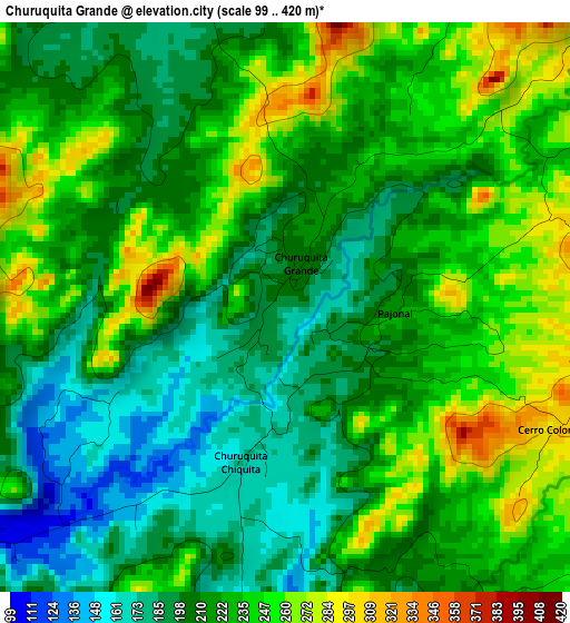
Below is the Elevation map of Churuquita Grande, which displays elevation range with different colors. Scale of the first map is from 99 to 420 m (325 to 1378 ft) with average elevation of 220.9 meters (=725 ft) [note 1]
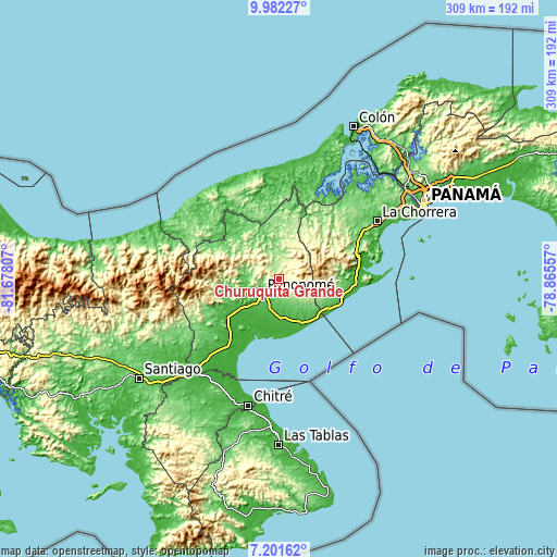
These maps also provides idea of topography and contour of this city, they are displayed at different zoom levels. More info about maps, scale and edge coordinates you can find below images.
| \ | Map #1 | Topo.Map |
| Scale [m] | 99..420 m | × |
| Scale [ft] | 325..1378 ft | × |
| Average | 220.9 m = 725 ft | × |
| Width | 9.66 km = 6 mi | 309.2 km = 192.1 mi |
| Height | 9.66 km = 6 mi | 309.2 km = 192.1 mi |
| ↑Max Latitude | 8.637939° | 9.98227° |
| Latitude at center | 8.59449° | 8.59449° |
| ↓Min Latitude | 8.551036° | 7.20162° |
| ← Min Longitude | -80.315765° | -81.67807° |
| Longitude center | -80.27182° | -80.27182° |
| →Max Longitude | -80.227875° | -78.86557° |
Nearby cities:
Cities around Churuquita Grande sort by population:
• Penonomé elevation 90 m
12.6 km,  228°
228°
• Chigoré 92 m
11.3 km, 230°
• Churuquita Chiquita 175 m
2.1 km,  179°
179°
• Alto de La Estancia 517 m
9.6 km,  94°
94°
• Aguas Blancas 77 m
11 km,  203°
203°
• Entradero 346 m
7.6 km,  111°
111°
• Caimito 274 m
4.8 km,  48°
48°
• Toabré 201 m
8.3 km,  319°
319°
• Chiguirí Arriba 296 m
12.5 km, 46°
• San Juan de Dios 262 m
7 km,  133°
133°
• Caballero 304 m
9.9 km,  124°
124°
• Cabuya 391 m
12.6 km, 114°
Multilingual:
 En español:
Churuquita Grande elevación 175 m.
 En France:
Churuquita Grande élévation 175 m.
 Auf Deutsch:
Churuquita Grande höhe über dem Meeresspiegel ist 175 m.

Sources and notes:
- [note 1] Map square and city borders are not equal. Map elevation data is calculated only from area inside that square.
- [src 1] Elevation data from geonames database provided with same terms of usage.
- [src 2] The elevation map of Churuquita Grande is generated using elevation data from NASA's 3 arcsec (90m) resolution SRTM data.
- [src 3] Base (background) map © OpenStreetMap contributors tiles are generated by Geofabrik and OpenTopoMap.
Copyright & License:
This Churuquita Grande Elevation Map is licensed under CC BY-SA. You may reuse any part from this page, if you give a proper credit by linking to this URL:
 More info on terms of use page.