Khasab elevation
Khasab (Musandam), Oman elevation is 13 meters and Khasab elevation in feet is 43 ft above sea level [src 1]. Khasab is a seat of a first-order administrative division (feature code) with elevation that is 194 meters (636 ft) smaller than average city elevation in Oman.
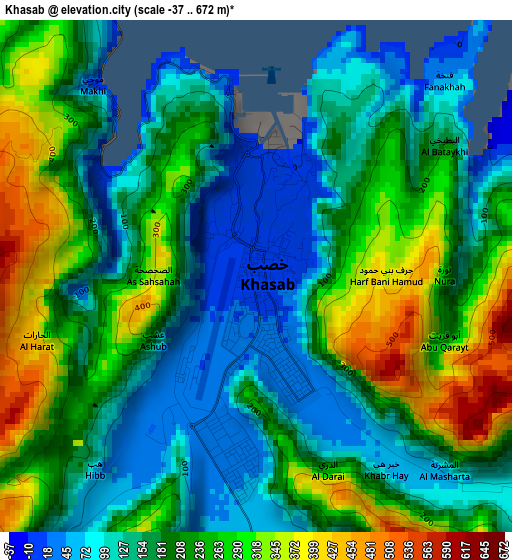
Below is the Elevation map of Khasab, which displays elevation range with different colors. Scale of the first map is from -37 to 672 m (-121 to 2205 ft) with average elevation of 201.3 meters (=660 ft) [note 1]
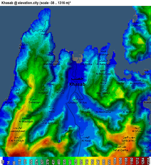
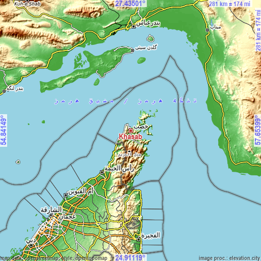
These maps also provides idea of topography and contour of this city, they are displayed at different zoom levels. More info about maps, scale and edge coordinates you can find below images.
| \ | Map #1 | Map #2 | Topo.Map |
| Scale [m] | -37..672 m | -38..1316 m | × |
| Scale [ft] | -121..2205 ft | -125..4318 ft | × |
| Average | 201.3 m = 660 ft | 332.7 m = 1092 ft | × |
| Width | 8.77 km = 5.4 mi | 17.54 km = 10.9 mi | 280.6 km = 174.4 mi |
| Height | 8.77 km = 5.4 mi | 17.54 km = 10.9 mi | 280.6 km = 174.4 mi |
| ↑Max Latitude | 26.21936° | 26.258777° | 27.43501° |
| Latitude at center | 26.17993° | 26.17993° | 26.17993° |
| ↓Min Latitude | 26.140486° | 26.101029° | 24.91119° |
| ← Min Longitude | 56.203795° | 56.159849° | 54.84149° |
| Longitude center | 56.24774° | 56.24774° | 56.24774° |
| →Max Longitude | 56.291685° | 56.335631° | 57.65399° |
Nearby cities:
Cities around Khasab sort by population:
• Sohar elevation 12 m
209 km,  167°
167°
• As Suwayq 6 m
285.6 km,  155°
155°
• Şaḩam 2 m
232.4 km, 163°
• Barkā’ 14 m
323.5 km,  149°
149°
• Al Buraymī 297 m
219.3 km,  192°
192°
• Al Khābūrah 4 m
259.9 km, 160°
• Shināş 3 m
161.3 km, 172°
• Liwá 5 m
186.1 km, 170°
• Oman Smart Future City 69 m
312.3 km, 154°
• Yanqul 684 m
289.9 km, 174°
• Dib Dibba 1 m
2.2 km,  26°
26°
• Madḩā’ al Jadīdah 58 m
100 km,  175°
175°
Multilingual:
 En español:
Jasab elevación 13 m.
 En France:
Khasab élévation 13 m.
 Auf Deutsch:
al-Chasab höhe über dem Meeresspiegel ist 13 m.

Sources and notes:
- [note 1] Map square and city borders are not equal. Map elevation data is calculated only from area inside that square.
- [src 1] Elevation data from geonames database provided with same terms of usage.
- [src 2] The elevation map of Khasab is generated using elevation data from NASA's 3 arcsec (90m) resolution SRTM data.
- [src 3] Base (background) map © OpenStreetMap contributors tiles are generated by Geofabrik and OpenTopoMap.
Copyright & License:
This Khasab Elevation Map is licensed under CC BY-SA. You may reuse any part from this page, if you give a proper credit by linking to this URL:
 More info on terms of use page.