Wiri elevation
Wiri (Auckland), New Zealand elevation is 23 meters and Wiri elevation in feet is 75 ft above sea level [src 1]. Wiri is a section of populated place (feature code) with elevation that is 54 meters (177 ft) smaller than average city elevation in New Zealand.
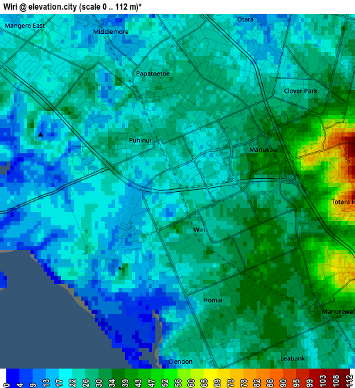
Below is the Elevation map of Wiri, which displays elevation range with different colors. Scale of the first map is from 0 to 112 m (0 to 367 ft) with average elevation of 25.9 meters (=85 ft) [note 1]
These maps also provides idea of topography and contour of this city, they are displayed at different zoom levels. More info about maps, scale and edge coordinates you can find below images.
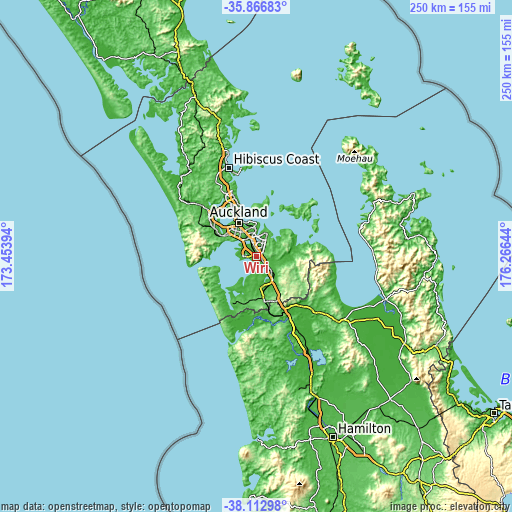
| \ | Map #1 | Map #2 | Topo.Map |
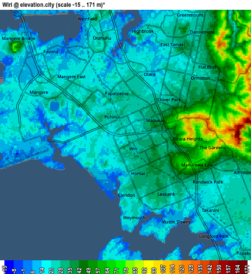
| Scale [m] | 0..112 m | -15..171 m | × |
| Scale [ft] | 0..367 ft | -49..561 ft | × |
| Average | 25.9 m = 85 ft | 29.4 m = 96 ft | × |
| Width | 7.8 km = 4.8 mi | 15.61 km = 9.7 mi | 249.7 km = 155.2 mi |
| Height | 7.8 km = 4.8 mi | 15.61 km = 9.7 mi | 249.7 km = 155.2 mi |
| ↑Max Latitude | -36.963095° | -36.927973° | -35.86683° |
| Latitude at center | -36.9982° | -36.9982° | -36.9982° |
| ↓Min Latitude | -37.033289° | -37.068362° | -38.11298° |
| ← Min Longitude | 174.816245° | 174.772299° | 173.45394° |
| Longitude center | 174.86019° | 174.86019° | 174.86019° |
| →Max Longitude | 174.904135° | 174.948081° | 176.26644° |
Nearby cities:
Cities around Wiri sort by population:
• Auckland elevation 43 m
18.7 km,  332°
332°
• Manukau City 43 m
1.8 km,  71°
71°
• Waitakere 87 m
20.1 km,  296°
296°
• Mangere 15 m
6.4 km, 301°
• Papakura 27 m
10.6 km,  135°
135°
• Pukekohe East 115 m
23.8 km,  160°
160°
• Takanini 18 m
6.6 km,  147°
147°
• Pakuranga 36 m
13.7 km,  21°
21°
• Rosebank 19 m
21.8 km,  309°
309°
• Tamaki 28 m
12.2 km,  0°
0°
• Titirangi 162 m
19.4 km,  290°
290°
• Red Hill 32 m
11.8 km,  124°
124°
Multilingual:
 En español:
Wiri elevación 23 m.
 En France:
Wiri élévation 23 m.


Sources and notes:
- [note 1] Map square and city borders are not equal. Map elevation data is calculated only from area inside that square.
- [src 1] Elevation data from geonames database provided with same terms of usage.
- [src 2] The elevation map of Wiri is generated using elevation data from NASA's 3 arcsec (90m) resolution SRTM data.
- [src 3] Base (background) map © OpenStreetMap contributors tiles are generated by Geofabrik and OpenTopoMap.
Copyright & License:
This Wiri Elevation Map is licensed under CC BY-SA. You may reuse any part from this page, if you give a proper credit by linking to this URL:
 More info on terms of use page.