Oamaru elevation
Oamaru (Otago), New Zealand elevation is 12 meters and Oamaru elevation in feet is 39 ft above sea level [src 1]. Oamaru is a populated place (feature code) with elevation that is 65 meters (213 ft) smaller than average city elevation in New Zealand.
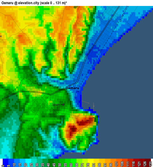
Below is the Elevation map of Oamaru, which displays elevation range with different colors. Scale of the first map is from 0 to 131 m (0 to 430 ft) with average elevation of 52.2 meters (=171 ft) [note 1]
These maps also provides idea of topography and contour of this city, they are displayed at different zoom levels. More info about maps, scale and edge coordinates you can find below images.
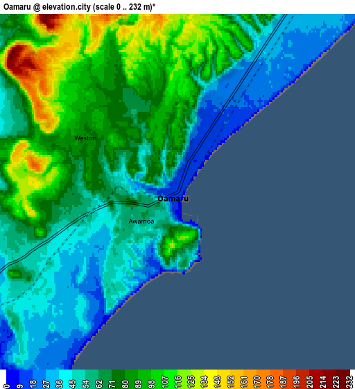
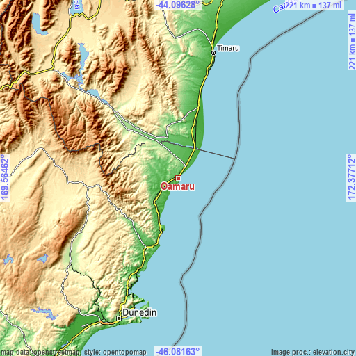
| \ | Map #1 | Map #2 | Topo.Map |
| Scale [m] | 0..131 m | 0..232 m | × |
| Scale [ft] | 0..430 ft | 0..761 ft | × |
| Average | 52.2 m = 171 ft | 70.3 m = 231 ft | × |
| Width | 6.9 km = 4.3 mi | 13.8 km = 8.6 mi | 220.8 km = 137.2 mi |
| Height | 6.9 km = 4.3 mi | 13.8 km = 8.6 mi | 220.7 km = 137.1 mi |
| ↑Max Latitude | -45.066551° | -45.035504° | -44.09628° |
| Latitude at center | -45.09758° | -45.09758° | -45.09758° |
| ↓Min Latitude | -45.128593° | -45.159588° | -46.08163° |
| ← Min Longitude | 170.926925° | 170.882979° | 169.56462° |
| Longitude center | 170.97087° | 170.97087° | 170.97087° |
| →Max Longitude | 171.014815° | 171.058761° | 172.37712° |
Nearby cities:
Cities around Oamaru sort by population:
• Dunedin elevation 21 m
93.7 km,  202°
202°
• Ashburton 106 m
146.3 km,  24°
24°
• Timaru 14 m
81.1 km, 15°
• Cromwell 212 m
139.2 km,  272°
272°
• Balclutha 27 m
158 km,  216°
216°
• Wanaka 325 m
150.1 km,  287°
287°
• Tinwald 102 m
144 km, 24°
• Geraldine 119 m
114 km,  10°
10°
• Arrowtown 652 m
170.7 km,  275°
275°
• Milton 20 m
137.9 km,  214°
214°
• Portobello 77 m
87.3 km, 196°
• Pleasant Point 89 m
93.3 km, 7°
Multilingual:
 En español:
Oamaru elevación 12 m.
 En France:
Oamaru élévation 12 m.


Sources and notes:
- [note 1] Map square and city borders are not equal. Map elevation data is calculated only from area inside that square.
- [src 1] Elevation data from geonames database provided with same terms of usage.
- [src 2] The elevation map of Oamaru is generated using elevation data from NASA's 3 arcsec (90m) resolution SRTM data.
- [src 3] Base (background) map © OpenStreetMap contributors tiles are generated by Geofabrik and OpenTopoMap.
Copyright & License:
This Oamaru Elevation Map is licensed under CC BY-SA. You may reuse any part from this page, if you give a proper credit by linking to this URL:
 More info on terms of use page.