Queenstown elevation
Queenstown (Otago, Queenstown-Lakes District), New Zealand elevation is 328 meters and Queenstown elevation in feet is 1076 ft above sea level [src 1]. Queenstown is a populated place (feature code) with elevation that is 251 meters (823 ft) bigger than average city elevation in New Zealand.
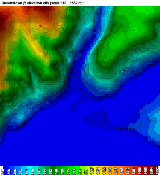
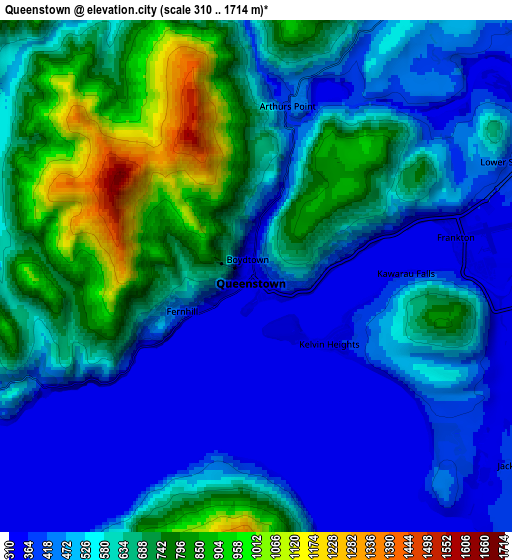
Below is the Elevation map of Queenstown, which displays elevation range with different colors. Scale of the first map is from 310 to 1552 m (1017 to 5092 ft) with average elevation of 555 meters (=1821 ft) [note 1]
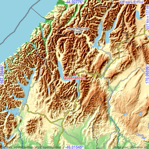
These maps also provides idea of topography and contour of this city, they are displayed at different zoom levels. More info about maps, scale and edge coordinates you can find below images.
| \ | Map #1 | Map #2 | Topo.Map |
| Scale [m] | 310..1552 m | 310..1714 m | × |
| Scale [ft] | 1017..5092 ft | 1017..5623 ft | × |
| Average | 555 m = 1821 ft | 574 m = 1883 ft | × |
| Width | 6.91 km = 4.3 mi | 13.81 km = 8.6 mi | 221 km = 137.3 mi |
| Height | 6.91 km = 4.3 mi | 13.81 km = 8.6 mi | 221 km = 137.3 mi |
| ↑Max Latitude | -44.999164° | -44.968081° | -44.02776° |
| Latitude at center | -45.03023° | -45.03023° | -45.03023° |
| ↓Min Latitude | -45.061279° | -45.092312° | -46.01545° |
| ← Min Longitude | 168.618765° | 168.574819° | 167.25646° |
| Longitude center | 168.66271° | 168.66271° | 168.66271° |
| →Max Longitude | 168.706655° | 168.750601° | 170.06896° |
Nearby cities:
Cities around Queenstown sort by population:
• Dunedin elevation 21 m
171.5 km,  123°
123°
• Invercargill 6 m
154.2 km,  189°
189°
• Gore 75 m
121.2 km,  169°
169°
• Cromwell 212 m
42.2 km,  91°
91°
• Balclutha 27 m
158.3 km,  147°
147°
• Wanaka 325 m
53.1 km,  46°
46°
• Kingston 626 m
33.9 km, 173°
• Winton 51 m
127.1 km, 191°
• Arrowtown 652 m
15.4 km, 48°
• Te Anau 215 m
85.6 km,  239°
239°
• Milton 20 m
158.3 km,  140°
140°
• Riverton 7 m
155.1 km,  198°
198°
Multilingual:
 En español:
Queenstown elevación 328 m.
 En France:
Queenstown élévation 328 m.
 Auf Deutsch:
Queenstown höhe über dem Meeresspiegel ist 328 m.

Sources and notes:
- [note 1] Map square and city borders are not equal. Map elevation data is calculated only from area inside that square.
- [src 1] Elevation data from geonames database provided with same terms of usage.
- [src 2] The elevation map of Queenstown is generated using elevation data from NASA's 3 arcsec (90m) resolution SRTM data.
- [src 3] Base (background) map © OpenStreetMap contributors tiles are generated by Geofabrik and OpenTopoMap.
Copyright & License:
This Queenstown Elevation Map is licensed under CC BY-SA. You may reuse any part from this page, if you give a proper credit by linking to this URL:
 More info on terms of use page.