Paraparaumu elevation
Paraparaumu (Wellington, Kapiti Coast District), New Zealand elevation is 77 meters and Paraparaumu elevation in feet is 253 ft above sea level [src 1]. Paraparaumu is a populated place (feature code) with elevation that is 0 meters (0 ft) bigger than average city elevation in New Zealand.
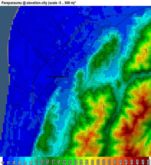
Below is the Elevation map of Paraparaumu, which displays elevation range with different colors. Scale of the first map is from -5 to 508 m (-16 to 1667 ft) with average elevation of 110.4 meters (=362 ft) [note 1]
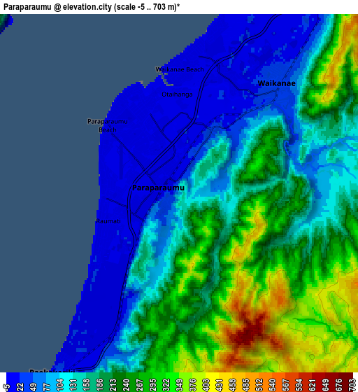
These maps also provides idea of topography and contour of this city, they are displayed at different zoom levels. More info about maps, scale and edge coordinates you can find below images.
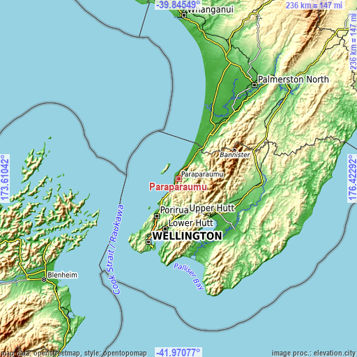
| \ | Map #1 | Map #2 | Topo.Map |
| Scale [m] | -5..508 m | -5..703 m | × |
| Scale [ft] | -16..1667 ft | -16..2306 ft | × |
| Average | 110.4 m = 362 ft | 174.8 m = 573 ft | × |
| Width | 7.38 km = 4.6 mi | 14.77 km = 9.2 mi | 236.3 km = 146.8 mi |
| Height | 7.38 km = 4.6 mi | 14.77 km = 9.2 mi | 236.3 km = 146.8 mi |
| ↑Max Latitude | -40.883454° | -40.850221° | -39.84549° |
| Latitude at center | -40.91667° | -40.91667° | -40.91667° |
| ↓Min Latitude | -40.94987° | -40.983052° | -41.97077° |
| ← Min Longitude | 174.972725° | 174.928779° | 173.61042° |
| Longitude center | 175.01667° | 175.01667° | 175.01667° |
| →Max Longitude | 175.060615° | 175.104561° | 176.42292° |
Nearby cities:
Cities around Paraparaumu sort by population:
• Wellington elevation 31 m
45.8 km,  206°
206°
• Lower Hutt 9 m
34.4 km,  194°
194°
• Porirua 58 m
27.9 km, 210°
• Upper Hutt 60 m
24.8 km,  173°
173°
• Masterton 103 m
54 km,  95°
95°
• Levin 38 m
38.3 km,  34°
34°
• Khandallah 176 m
41 km, 207°
• Petone 114 m
36.8 km,  199°
199°
• Otaki 15 m
20.9 km, 32°
• Foxton 16 m
55.4 km, 25°
• Brooklyn 137 m
48.2 km, 206°
• Kelburn 100 m
45.8 km, 207°
Multilingual:
 En español:
Paraparaumu elevación 77 m.
 En France:
Paraparaumu élévation 77 m.
 Auf Deutsch:
Paraparaumu höhe über dem Meeresspiegel ist 77 m.

Sources and notes:
- [note 1] Map square and city borders are not equal. Map elevation data is calculated only from area inside that square.
- [src 1] Elevation data from geonames database provided with same terms of usage.
- [src 2] The elevation map of Paraparaumu is generated using elevation data from NASA's 3 arcsec (90m) resolution SRTM data.
- [src 3] Base (background) map © OpenStreetMap contributors tiles are generated by Geofabrik and OpenTopoMap.
Copyright & License:
This Paraparaumu Elevation Map is licensed under CC BY-SA. You may reuse any part from this page, if you give a proper credit by linking to this URL:
 More info on terms of use page.