Prebbleton elevation
Prebbleton (Canterbury, Selwyn District), New Zealand elevation is 21 meters and Prebbleton elevation in feet is 69 ft above sea level [src 1]. Prebbleton is a populated place (feature code) with elevation that is 56 meters (184 ft) smaller than average city elevation in New Zealand.
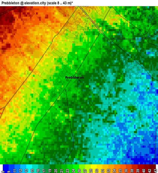
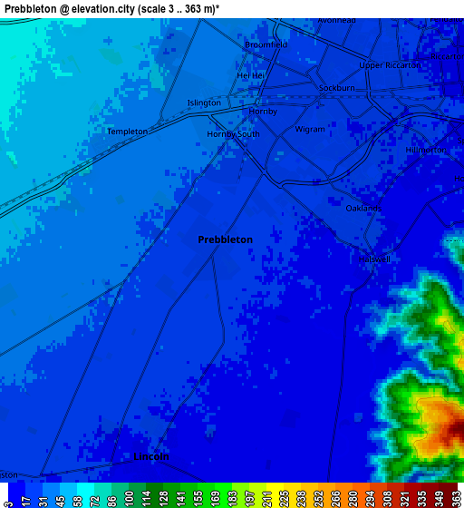
Below is the Elevation map of Prebbleton, which displays elevation range with different colors. Scale of the first map is from 8 to 43 m (26 to 141 ft) with average elevation of 23 meters (=75 ft) [note 1]
These maps also provides idea of topography and contour of this city, they are displayed at different zoom levels. More info about maps, scale and edge coordinates you can find below images.
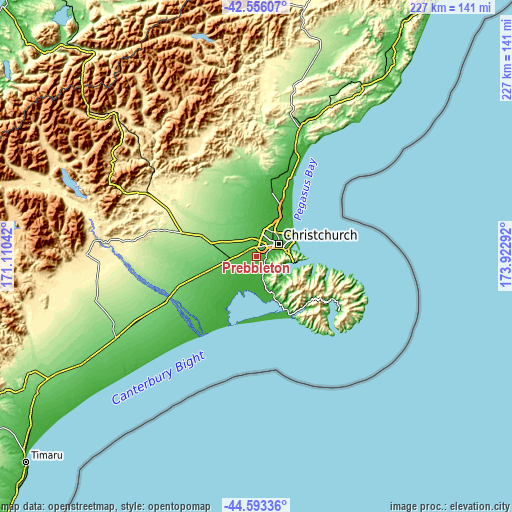
| \ | Map #1 | Map #2 | Topo.Map |
| Scale [m] | 8..43 m | 3..363 m | × |
| Scale [ft] | 26..141 ft | 10..1191 ft | × |
| Average | 23 m = 75 ft | 33.9 m = 111 ft | × |
| Width | 7.08 km = 4.4 mi | 14.16 km = 8.8 mi | 226.5 km = 140.7 mi |
| Height | 7.08 km = 4.4 mi | 14.16 km = 8.8 mi | 226.5 km = 140.7 mi |
| ↑Max Latitude | -43.551489° | -43.519631° | -42.55607° |
| Latitude at center | -43.58333° | -43.58333° | -43.58333° |
| ↓Min Latitude | -43.615154° | -43.646962° | -44.59336° |
| ← Min Longitude | 172.472725° | 172.428779° | 171.11042° |
| Longitude center | 172.51667° | 172.51667° | 172.51667° |
| →Max Longitude | 172.560615° | 172.604561° | 173.92292° |
Nearby cities:
Cities around Prebbleton sort by population:
• Christchurch elevation 14 m
10.9 km,  59°
59°
• Kaiapoi 4 m
24.9 km,  23°
23°
• Rolleston 60 m
10.7 km,  270°
270°
• Woodend 13 m
32 km, 22°
• Lincoln 8 m
7.9 km,  199°
199°
• Oxford 244 m
41.4 km,  319°
319°
• Darfield 204 m
34.1 km,  289°
289°
• Leeston 18 m
26.8 km,  220°
220°
• Burnham 62 m
16.5 km,  257°
257°
• Methven 319 m
70 km, 265°
• Amberley 46 m
50.6 km, 19°
• Rakaia 118 m
44.3 km,  245°
245°
Multilingual:
 En español:
Prebbleton elevación 21 m.
 En France:
Prebbleton élévation 21 m.
 Auf Deutsch:
Prebbleton höhe über dem Meeresspiegel ist 21 m.

Sources and notes:
- [note 1] Map square and city borders are not equal. Map elevation data is calculated only from area inside that square.
- [src 1] Elevation data from geonames database provided with same terms of usage.
- [src 2] The elevation map of Prebbleton is generated using elevation data from NASA's 3 arcsec (90m) resolution SRTM data.
- [src 3] Base (background) map © OpenStreetMap contributors tiles are generated by Geofabrik and OpenTopoMap.
Copyright & License:
This Prebbleton Elevation Map is licensed under CC BY-SA. You may reuse any part from this page, if you give a proper credit by linking to this URL:
 More info on terms of use page.