Hemsedal elevation
Hemsedal (Buskerud), Norway elevation is 620 meters and Hemsedal elevation in feet is 2034 ft above sea level [src 1]. Hemsedal is a populated place (feature code) with elevation that is 519 meters (1703 ft) bigger than average city elevation in Norway.
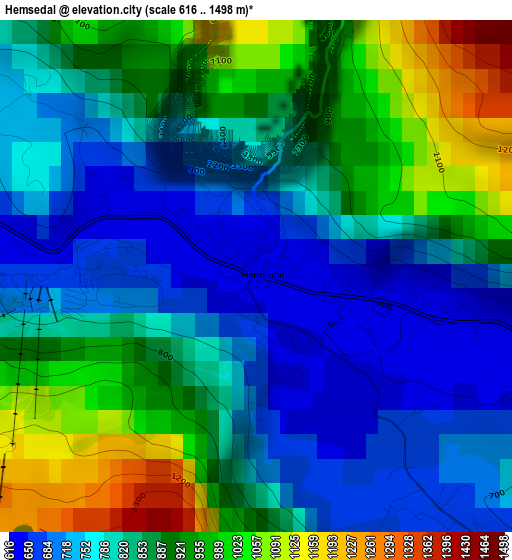
Below is the Elevation map of Hemsedal, which displays elevation range with different colors. Scale of the first map is from 616 to 1498 m (2021 to 4915 ft) with average elevation of 844.6 meters (=2771 ft) [note 1]
These maps also provides idea of topography and contour of this city, they are displayed at different zoom levels. More info about maps, scale and edge coordinates you can find below images.
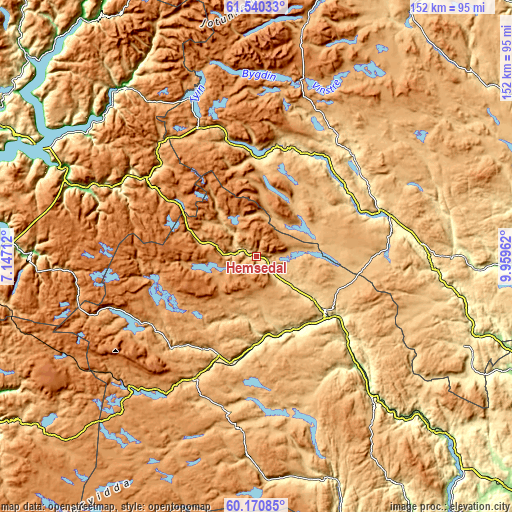
| \ | Map #1 | Topo.Map |
| Scale [m] | 616..1498 m | × |
| Scale [ft] | 2021..4915 ft | × |
| Average | 844.6 m = 2771 ft | × |
| Width | 4.76 km = 3 mi | 152.3 km = 94.6 mi |
| Height | 4.76 km = 3 mi | 152.3 km = 94.6 mi |
| ↑Max Latitude | 60.88432° | 61.54033° |
| Latitude at center | 60.86293° | 60.86293° |
| ↓Min Latitude | 60.841526° | 60.17085° |
| ← Min Longitude | 8.509425° | 7.14712° |
| Longitude center | 8.55337° | 8.55337° |
| →Max Longitude | 8.597315° | 9.95962° |
Nearby cities:
Cities around Hemsedal sort by population:
• Gol elevation 235 m
27.9 km,  130°
130°
• Ål 440 m
25.9 km,  179°
179°
• Geilo 800 m
41.2 km,  207°
207°
• Nesbyen 154 m
44.4 km,  137°
137°
• Fagernes 374 m
39.2 km,  69°
69°
• Bagn 222 m
54.3 km,  94°
94°
• Bruflat 331 m
58.9 km, 87°
• Heggenes 540 m
41.8 km,  41°
41°
• Slidre 420 m
34.1 km, 42°
• Hol 540 m
31 km, 207°
• Vang 466 m
29.2 km,  2°
2°
• Trøim 620 m
0.7 km,  107°
107°
Multilingual:
 En español:
Hemsedal elevación 620 m.
 En France:
Hemsedal élévation 620 m.
 Auf Deutsch:
Hemsedal höhe über dem Meeresspiegel ist 620 m.

Sources and notes:
- [note 1] Map square and city borders are not equal. Map elevation data is calculated only from area inside that square.
- [src 1] Elevation data from geonames database provided with same terms of usage.
- [src 2] The elevation map of Hemsedal is generated using GMTED2010 database with 7.5 arcsec (225m) resolution.
- [src 3] Base (background) map © OpenStreetMap contributors tiles are generated by Geofabrik and OpenTopoMap.
Copyright & License:
This Hemsedal Elevation Map is licensed under CC BY-SA. You may reuse any part from this page, if you give a proper credit by linking to this URL:
 More info on terms of use page.