Hundorp elevation
Hundorp (Oppland, Sør-Fron), Norway elevation is 270 meters and Hundorp elevation in feet is 886 ft above sea level [src 1]. Hundorp is a seat of a second-order administrative division (feature code) with elevation that is 169 meters (554 ft) bigger than average city elevation in Norway.
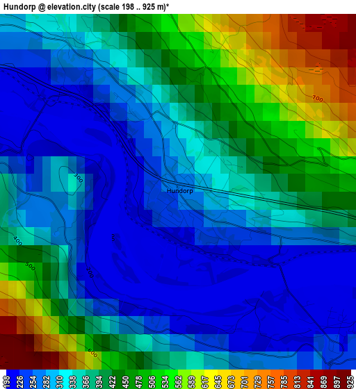
Below is the Elevation map of Hundorp, which displays elevation range with different colors. Scale of the first map is from 198 to 925 m (650 to 3035 ft) with average elevation of 365.2 meters (=1198 ft) [note 1]
These maps also provides idea of topography and contour of this city, they are displayed at different zoom levels. More info about maps, scale and edge coordinates you can find below images.
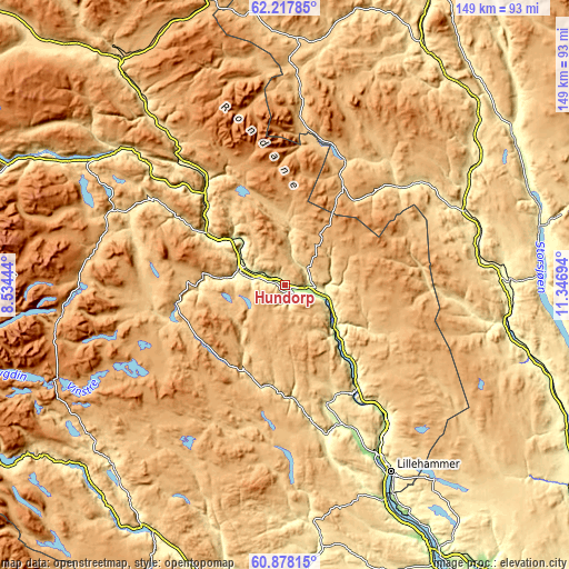
| \ | Map #1 | Topo.Map |
| Scale [m] | 198..925 m | × |
| Scale [ft] | 650..3035 ft | × |
| Average | 365.2 m = 1198 ft | × |
| Width | 4.65 km = 2.9 mi | 149 km = 92.6 mi |
| Height | 4.65 km = 2.9 mi | 148.9 km = 92.5 mi |
| ↑Max Latitude | 61.576155° | 62.21785° |
| Latitude at center | 61.55523° | 61.55523° |
| ↓Min Latitude | 61.534291° | 60.87815° |
| ← Min Longitude | 9.896745° | 8.53444° |
| Longitude center | 9.94069° | 9.94069° |
| →Max Longitude | 9.984635° | 11.34694° |
Nearby cities:
Cities around Hundorp sort by population:
• Lillehammer elevation 210 m
56.4 km,  150°
150°
• Vinstra 400 m
11 km,  293°
293°
• Otta 300 m
32.2 km,  318°
318°
• Vågåmo 400 m
56.9 km,  308°
308°
• Koppang 360 m
58.6 km,  88°
88°
• Tretten 300 m
32.9 km,  144°
144°
• Folldal 700 m
64.2 km,  2°
2°
• Dovre 540 m
60.1 km, 323°
• Bergset 284 m
70.6 km,  58°
58°
• Heggenes 540 m
65.2 km,  225°
225°
• Segalstad bru 320 m
39.3 km,  157°
157°
• Ringebu 200 m
10.9 km,  105°
105°
Multilingual:
 En español:
Hundorp elevación 270 m.
 En France:
Hundorp élévation 270 m.


Sources and notes:
- [note 1] Map square and city borders are not equal. Map elevation data is calculated only from area inside that square.
- [src 1] Elevation data from geonames database provided with same terms of usage.
- [src 2] The elevation map of Hundorp is generated using GMTED2010 database with 7.5 arcsec (225m) resolution.
- [src 3] Base (background) map © OpenStreetMap contributors tiles are generated by Geofabrik and OpenTopoMap.
Copyright & License:
This Hundorp Elevation Map is licensed under CC BY-SA. You may reuse any part from this page, if you give a proper credit by linking to this URL:
 More info on terms of use page.