Lillehammer elevation
Lillehammer (Oppland), Norway elevation is 210 meters and Lillehammer elevation in feet is 689 ft above sea level [src 1]. Lillehammer is a seat of a first-order administrative division (feature code) with elevation that is 109 meters (358 ft) bigger than average city elevation in Norway.
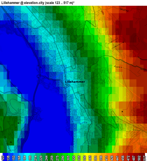
Below is the Elevation map of Lillehammer, which displays elevation range with different colors. Scale of the first map is from 123 to 517 m (404 to 1696 ft) with average elevation of 257.4 meters (=844 ft) [note 1]
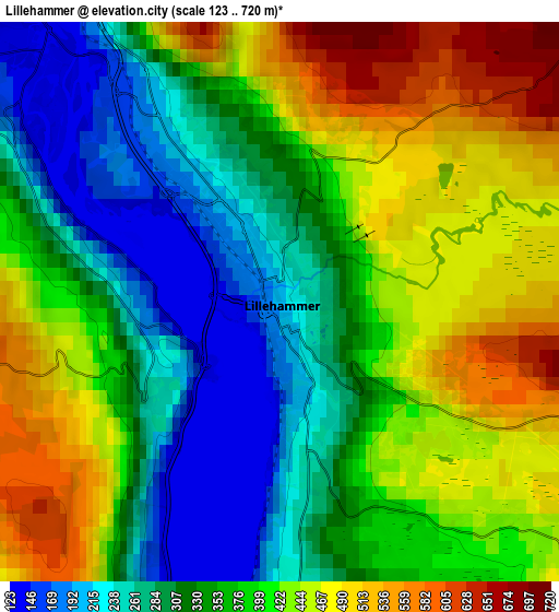
These maps also provides idea of topography and contour of this city, they are displayed at different zoom levels. More info about maps, scale and edge coordinates you can find below images.
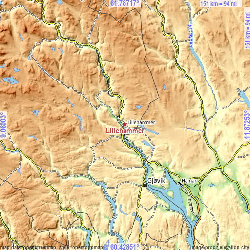
| \ | Map #1 | Map #2 | Topo.Map |
| Scale [m] | 123..517 m | 123..720 m | × |
| Scale [ft] | 404..1696 ft | 404..2362 ft | × |
| Average | 257.4 m = 844 ft | 372.2 m = 1221 ft | × |
| Width | 4.72 km = 2.9 mi | 9.44 km = 5.9 mi | 151.1 km = 93.9 mi |
| Height | 4.72 km = 2.9 mi | 9.44 km = 5.9 mi | 151 km = 93.8 mi |
| ↑Max Latitude | 61.136361° | 61.157567° | 61.78717° |
| Latitude at center | 61.11514° | 61.11514° | 61.11514° |
| ↓Min Latitude | 61.093905° | 61.072656° | 60.42851° |
| ← Min Longitude | 10.422335° | 10.378389° | 9.06003° |
| Longitude center | 10.46628° | 10.46628° | 10.46628° |
| →Max Longitude | 10.510225° | 10.554171° | 11.87253° |
Nearby cities:
Cities around Lillehammer sort by population:
• Hamar elevation 137 m
48.2 km,  137°
137°
• Gjøvik 127 m
37.5 km,  161°
161°
• Brumunddal 143 m
36.5 km, 135°
• Raufoss 324 m
44 km,  169°
169°
• Moelv 180 m
23.8 km,  148°
148°
• Dokka 180 m
37.7 km,  214°
214°
• Hov 270 m
46.7 km,  187°
187°
• Rena 220 m
48.6 km,  87°
87°
• Reinsvoll 367 m
49.1 km, 170°
• Tretten 300 m
23.8 km,  338°
338°
• Ringebu 200 m
49.3 km, 339°
• Segalstad bru 320 m
18.1 km,  313°
313°
Multilingual:
 En español:
Lillehammer elevación 210 m.
 En France:
Lillehammer élévation 210 m.
 Auf Deutsch:
Lillehammer höhe über dem Meeresspiegel ist 210 m.

Sources and notes:
- [note 1] Map square and city borders are not equal. Map elevation data is calculated only from area inside that square.
- [src 1] Elevation data from geonames database provided with same terms of usage.
- [src 2] The elevation map of Lillehammer is generated using GMTED2010 database with 7.5 arcsec (225m) resolution.
- [src 3] Base (background) map © OpenStreetMap contributors tiles are generated by Geofabrik and OpenTopoMap.
Copyright & License:
This Lillehammer Elevation Map is licensed under CC BY-SA. You may reuse any part from this page, if you give a proper credit by linking to this URL:
 More info on terms of use page.