Lærdalsøyri elevation
Lærdalsøyri (Sogn og Fjordane, Lærdal), Norway elevation is 60 meters and Lærdalsøyri elevation in feet is 197 ft above sea level [src 1]. Lærdalsøyri is a seat of a second-order administrative division (feature code) with elevation that is 41 meters (135 ft) smaller than average city elevation in Norway.
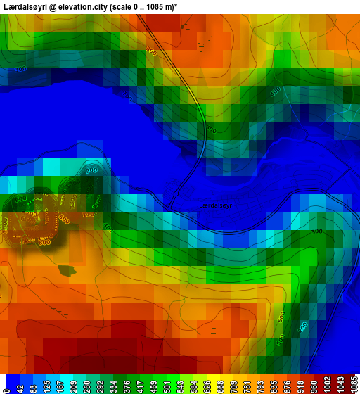
Below is the Elevation map of Lærdalsøyri, which displays elevation range with different colors. Scale of the first map is from 0 to 1085 m (0 to 3560 ft) with average elevation of 433.4 meters (=1422 ft) [note 1]
These maps also provides idea of topography and contour of this city, they are displayed at different zoom levels. More info about maps, scale and edge coordinates you can find below images.
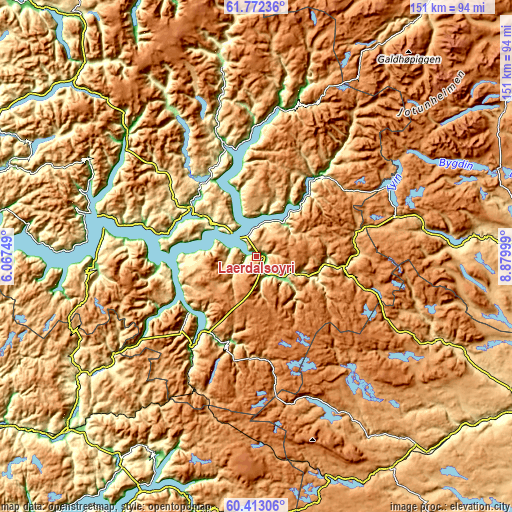
| \ | Map #1 | Topo.Map |
| Scale [m] | 0..1085 m | × |
| Scale [ft] | 0..3560 ft | × |
| Average | 433.4 m = 1422 ft | × |
| Width | 4.72 km = 2.9 mi | 151.1 km = 93.9 mi |
| Height | 4.72 km = 2.9 mi | 151.1 km = 93.9 mi |
| ↑Max Latitude | 61.121241° | 61.77236° |
| Latitude at center | 61.10001° | 61.10001° |
| ↓Min Latitude | 61.078765° | 60.41306° |
| ← Min Longitude | 7.429795° | 6.06749° |
| Longitude center | 7.47374° | 7.47374° |
| →Max Longitude | 7.517685° | 8.87999° |
Nearby cities:
Cities around Lærdalsøyri sort by population:
• Sogndal elevation 1 m
24.8 km,  305°
305°
• Farnes 60 m
28.9 km,  36°
36°
• Vik 684 m
48.4 km,  264°
264°
• Hermansverk 60 m
34.8 km,  285°
285°
• Hemsedal 620 m
63.9 km,  114°
114°
• Årdalstangen 20 m
19.5 km, 39°
• Gaupne 40 m
35.2 km,  344°
344°
• Balestrand 30 m
51.8 km,  283°
283°
• Vang 466 m
59.1 km,  87°
87°
• Vikøyri 13 m
48.1 km,  268°
268°
• Aurlandsvangen 27 m
26.6 km,  215°
215°
• Sogndalsfjøra 1 m
24.4 km, 305°
Multilingual:
 En español:
Lærdalsøyri elevación 60 m.
 En France:
Lærdalsøyri élévation 60 m.


Sources and notes:
- [note 1] Map square and city borders are not equal. Map elevation data is calculated only from area inside that square.
- [src 1] Elevation data from geonames database provided with same terms of usage.
- [src 2] The elevation map of Lærdalsøyri is generated using GMTED2010 database with 7.5 arcsec (225m) resolution.
- [src 3] Base (background) map © OpenStreetMap contributors tiles are generated by Geofabrik and OpenTopoMap.
Copyright & License:
This Lærdalsøyri Elevation Map is licensed under CC BY-SA. You may reuse any part from this page, if you give a proper credit by linking to this URL:
 More info on terms of use page.