Fossbergom elevation
Fossbergom (Oppland, Lom), Norway elevation is 440 meters and Fossbergom elevation in feet is 1444 ft above sea level [src 1]. Fossbergom is a seat of a second-order administrative division (feature code) with elevation that is 339 meters (1112 ft) bigger than average city elevation in Norway.
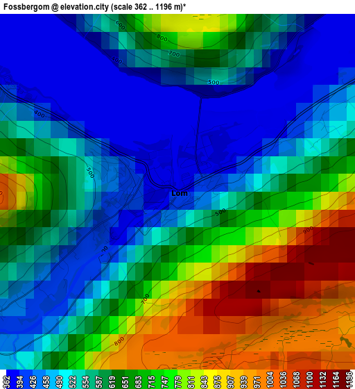
Below is the Elevation map of Fossbergom, which displays elevation range with different colors. Scale of the first map is from 362 to 1196 m (1188 to 3924 ft) with average elevation of 617 meters (=2024 ft) [note 1]
These maps also provides idea of topography and contour of this city, they are displayed at different zoom levels. More info about maps, scale and edge coordinates you can find below images.
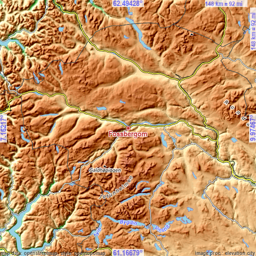
| \ | Map #1 | Topo.Map |
| Scale [m] | 362..1196 m | × |
| Scale [ft] | 1188..3924 ft | × |
| Average | 617 m = 2024 ft | × |
| Width | 4.61 km = 2.9 mi | 147.6 km = 91.7 mi |
| Height | 4.61 km = 2.9 mi | 147.6 km = 91.7 mi |
| ↑Max Latitude | 61.858454° | 62.49428° |
| Latitude at center | 61.83772° | 61.83772° |
| ↓Min Latitude | 61.816972° | 61.16679° |
| ← Min Longitude | 8.524475° | 7.16217° |
| Longitude center | 8.56842° | 8.56842° |
| →Max Longitude | 8.612365° | 9.97467° |
Nearby cities:
Cities around Fossbergom sort by population:
• Farnes elevation 60 m
71.6 km,  214°
214°
• Vinstra 400 m
67.9 km,  113°
113°
• Otta 300 m
51.3 km,  98°
98°
• Årdalstangen 20 m
81.1 km, 214°
• Vågåmo 400 m
28 km,  81°
81°
• Dombås 700 m
39.4 km,  47°
47°
• Hundorp 270 m
78.9 km, 113°
• Folldal 700 m
81.5 km,  66°
66°
• Dovre 540 m
39.6 km, 65°
• Vang 466 m
79.2 km,  179°
179°
• Lesja 660 m
34.8 km,  26°
26°
• Bismo 440 m
16.6 km,  288°
288°
Multilingual:
 En español:
Fossbergom elevación 440 m.
 En France:
Fossbergom élévation 440 m.


Sources and notes:
- [note 1] Map square and city borders are not equal. Map elevation data is calculated only from area inside that square.
- [src 1] Elevation data from geonames database provided with same terms of usage.
- [src 2] The elevation map of Fossbergom is generated using GMTED2010 database with 7.5 arcsec (225m) resolution.
- [src 3] Base (background) map © OpenStreetMap contributors tiles are generated by Geofabrik and OpenTopoMap.
Copyright & License:
This Fossbergom Elevation Map is licensed under CC BY-SA. You may reuse any part from this page, if you give a proper credit by linking to this URL:
 More info on terms of use page.