Råholt elevation
Råholt (Akershus, Eidsvoll), Norway elevation is 174 meters and Råholt elevation in feet is 571 ft above sea level [src 1]. Råholt is a populated place (feature code) with elevation that is 73 meters (240 ft) bigger than average city elevation in Norway.
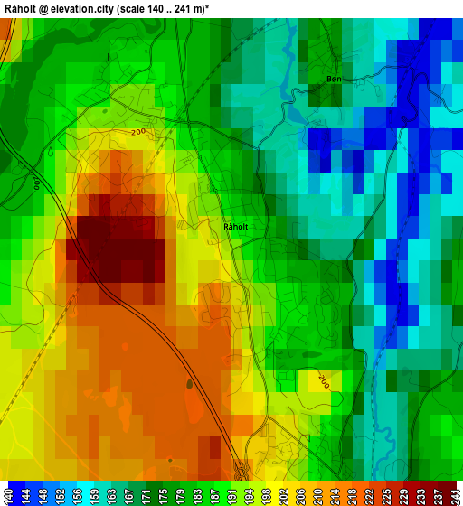
Below is the Elevation map of Råholt, which displays elevation range with different colors. Scale of the first map is from 140 to 241 m (459 to 791 ft) with average elevation of 186.3 meters (=611 ft) [note 1]
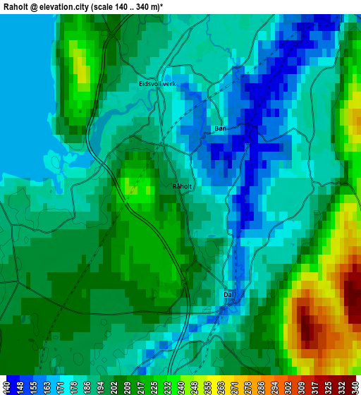
These maps also provides idea of topography and contour of this city, they are displayed at different zoom levels. More info about maps, scale and edge coordinates you can find below images.
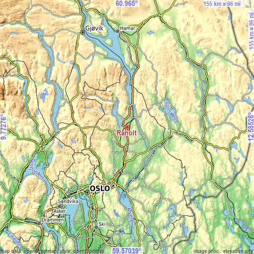
| \ | Map #1 | Map #2 | Topo.Map |
| Scale [m] | 140..241 m | 140..340 m | × |
| Scale [ft] | 459..791 ft | 459..1115 ft | × |
| Average | 186.3 m = 611 ft | 195.9 m = 643 ft | × |
| Width | 4.85 km = 3 mi | 9.69 km = 6 mi | 155.1 km = 96.4 mi |
| Height | 4.85 km = 3 mi | 9.69 km = 6 mi | 155 km = 96.3 mi |
| ↑Max Latitude | 60.296912° | 60.31868° | 60.965° |
| Latitude at center | 60.27513° | 60.27513° | 60.27513° |
| ↓Min Latitude | 60.253333° | 60.231522° | 59.57039° |
| ← Min Longitude | 11.135065° | 11.091119° | 9.77276° |
| Longitude center | 11.17901° | 11.17901° | 11.17901° |
| →Max Longitude | 11.222955° | 11.266901° | 12.58526° |
Nearby cities:
Cities around Råholt sort by population:
• Jessheim elevation 212 m
14.9 km,  180°
180°
• Kløfta 160 m
22.5 km,  185°
185°
• Årnes 140 m
23.4 km,  136°
136°
• Maura 200 m
8.3 km,  257°
257°
• Åneby 134 m
26.8 km,  219°
219°
• Neskollen 174 m
19.2 km,  152°
152°
• Ask 160 m
24 km,  199°
199°
• Fjellfoten 182 m
26.2 km, 141°
• Sand 160 m
23.8 km,  56°
56°
• Hurdal 270 m
18.8 km,  340°
340°
• Teigebyen 200 m
10.8 km,  235°
235°
• Eidsvoll 160 m
7.7 km,  36°
36°
Multilingual:
 En español:
Råholt elevación 174 m.
 En France:
Råholt élévation 174 m.


Sources and notes:
- [note 1] Map square and city borders are not equal. Map elevation data is calculated only from area inside that square.
- [src 1] Elevation data from geonames database provided with same terms of usage.
- [src 2] The elevation map of Råholt is generated using GMTED2010 database with 7.5 arcsec (225m) resolution.
- [src 3] Base (background) map © OpenStreetMap contributors tiles are generated by Geofabrik and OpenTopoMap.
Copyright & License:
This Råholt Elevation Map is licensed under CC BY-SA. You may reuse any part from this page, if you give a proper credit by linking to this URL:
 More info on terms of use page.