Achuapa elevation
Achuapa (León), Nicaragua elevation is 319 meters and Achuapa elevation in feet is 1047 ft above sea level [src 1]. Achuapa is a seat of a second-order administrative division (feature code) with elevation that is 22 meters (72 ft) smaller than average city elevation in Nicaragua.
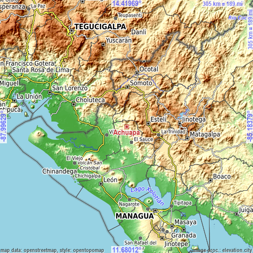
Below is the Elevation map of Achuapa, which displays elevation range with different colors. Scale of the first map is from 221 to 740 m (725 to 2428 ft) with average elevation of 413.5 meters (=1357 ft) [note 1]
These maps also provides idea of topography and contour of this city, they are displayed at different zoom levels. More info about maps, scale and edge coordinates you can find below images.

| \ | Map #1 | Topo.Map |
| Scale [m] | 221..740 m | × |
| Scale [ft] | 725..2428 ft | × |
| Average | 413.5 m = 1357 ft | × |
| Width | 9.52 km = 5.9 mi | 304.6 km = 189.3 mi |
| Height | 9.52 km = 5.9 mi | 304.6 km = 189.3 mi |
| ↑Max Latitude | 13.096506° | 14.41969° |
| Latitude at center | 13.0537° | 13.0537° |
| ↓Min Latitude | 13.010887° | 11.68012° |
| ← Min Longitude | -86.633985° | -87.99629° |
| Longitude center | -86.59004° | -86.59004° |
| →Max Longitude | -86.546095° | -85.18379° |
Nearby cities:
Cities around Achuapa sort by population:
• Estelí elevation 840 m
25.9 km,  80°
80°
• Somotillo 46 m
34.1 km,  268°
268°
• El Sauce 173 m
19.4 km,  163°
163°
• San Juan de Limay 284 m
13.8 km,  349°
349°
• Pueblo Nuevo 612 m
38.1 km,  18°
18°
• Santa Rosa del Peñón 176 m
36.8 km,  139°
139°
• San José de Cusmapa 1288 m
27 km,  344°
344°
• Las Sabanas 1252 m
32.4 km, 353°
• Cinco Pinos 409 m
35.9 km,  303°
303°
• San Nicolás 990 m
29.5 km,  117°
117°
• Villanueva 49 m
26.4 km,  247°
247°
• San Francisco del Norte 394 m
25.4 km,  309°
309°
Multilingual:
 En español:
Achuapa elevación 319 m.
 En France:
Achuapa élévation 319 m.


Sources and notes:
- [note 1] Map square and city borders are not equal. Map elevation data is calculated only from area inside that square.
- [src 1] Elevation data from geonames database provided with same terms of usage.
- [src 2] The elevation map of Achuapa is generated using elevation data from NASA's 3 arcsec (90m) resolution SRTM data.
- [src 3] Base (background) map © OpenStreetMap contributors tiles are generated by Geofabrik and OpenTopoMap.
Copyright & License:
This Achuapa Elevation Map is licensed under CC BY-SA. You may reuse any part from this page, if you give a proper credit by linking to this URL:
 More info on terms of use page.