Somotillo elevation
Somotillo (Chinandega), Nicaragua elevation is 46 meters and Somotillo elevation in feet is 151 ft above sea level [src 1]. Somotillo is a seat of a second-order administrative division (feature code) with elevation that is 295 meters (968 ft) smaller than average city elevation in Nicaragua.
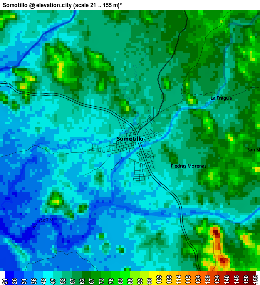
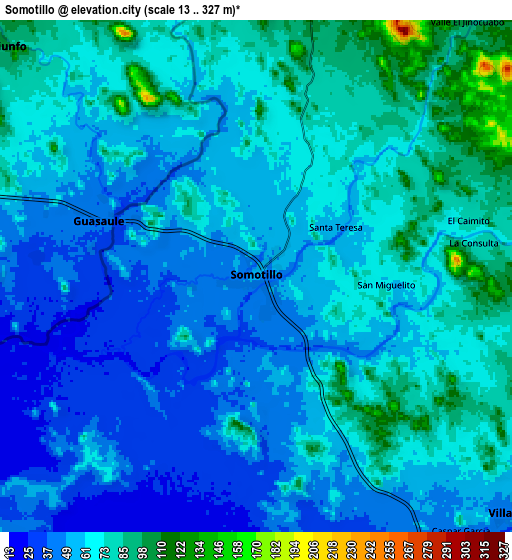
Below is the Elevation map of Somotillo, which displays elevation range with different colors. Scale of the first map is from 21 to 155 m (69 to 509 ft) with average elevation of 53 meters (=174 ft) [note 1]
These maps also provides idea of topography and contour of this city, they are displayed at different zoom levels. More info about maps, scale and edge coordinates you can find below images.
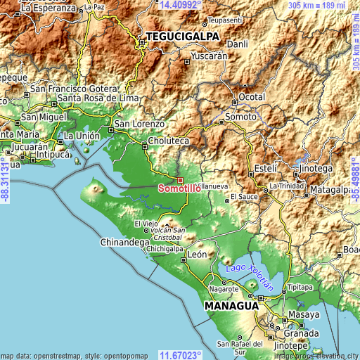
| \ | Map #1 | Map #2 | Topo.Map |
| Scale [m] | 21..155 m | 13..327 m | × |
| Scale [ft] | 69..509 ft | 43..1073 ft | × |
| Average | 53 m = 174 ft | 62.5 m = 205 ft | × |
| Width | 9.52 km = 5.9 mi | 19.04 km = 11.8 mi | 304.6 km = 189.3 mi |
| Height | 9.52 km = 5.9 mi | 19.04 km = 11.8 mi | 304.7 km = 189.3 mi |
| ↑Max Latitude | 13.086678° | 13.129478° | 14.40992° |
| Latitude at center | 13.04387° | 13.04387° | 13.04387° |
| ↓Min Latitude | 13.001055° | 12.958232° | 11.67023° |
| ← Min Longitude | -86.949005° | -86.992951° | -88.31131° |
| Longitude center | -86.90506° | -86.90506° | -86.90506° |
| →Max Longitude | -86.861115° | -86.817169° | -85.49881° |
Nearby cities:
Cities around Somotillo sort by population:
• El Sauce elevation 173 m
43.3 km,  113°
113°
• Puerto Morazán 9 m
36 km,  233°
233°
• San Juan de Limay 284 m
34.9 km,  65°
65°
• Achuapa 319 m
34.1 km,  88°
88°
• San José de Cusmapa 1288 m
38.3 km,  44°
44°
• Las Sabanas 1252 m
45.2 km, 42°
• Cinco Pinos 409 m
21 km,  10°
10°
• Santo Tomás del Norte 174 m
15.9 km,  353°
353°
• Tonalá 33 m
39.5 km,  218°
218°
• San Pedro del Norte 494 m
26 km, 6°
• San Francisco del Norte 394 m
22.6 km, 40°
• Villanueva 49 m
13.2 km,  132°
132°
Multilingual:
 En español:
Somotillo elevación 46 m.
 En France:
Somotillo élévation 46 m.
 Auf Deutsch:
Somotillo höhe über dem Meeresspiegel ist 46 m.

Sources and notes:
- [note 1] Map square and city borders are not equal. Map elevation data is calculated only from area inside that square.
- [src 1] Elevation data from geonames database provided with same terms of usage.
- [src 2] The elevation map of Somotillo is generated using elevation data from NASA's 3 arcsec (90m) resolution SRTM data.
- [src 3] Base (background) map © OpenStreetMap contributors tiles are generated by Geofabrik and OpenTopoMap.
Copyright & License:
This Somotillo Elevation Map is licensed under CC BY-SA. You may reuse any part from this page, if you give a proper credit by linking to this URL:
 More info on terms of use page.