Acoyapa elevation
Acoyapa (Chontales), Nicaragua elevation is 101 meters and Acoyapa elevation in feet is 331 ft above sea level [src 1]. Acoyapa is a seat of a second-order administrative division (feature code) with elevation that is 240 meters (787 ft) smaller than average city elevation in Nicaragua.
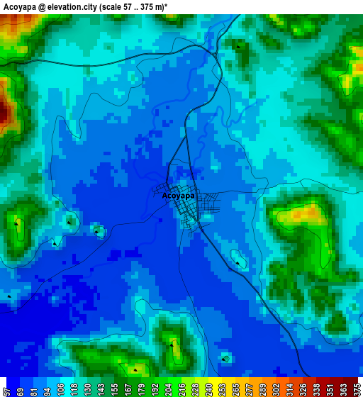
Below is the Elevation map of Acoyapa, which displays elevation range with different colors. Scale of the first map is from 57 to 375 m (187 to 1230 ft) with average elevation of 113.9 meters (=374 ft) [note 1]
These maps also provides idea of topography and contour of this city, they are displayed at different zoom levels. More info about maps, scale and edge coordinates you can find below images.
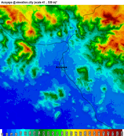
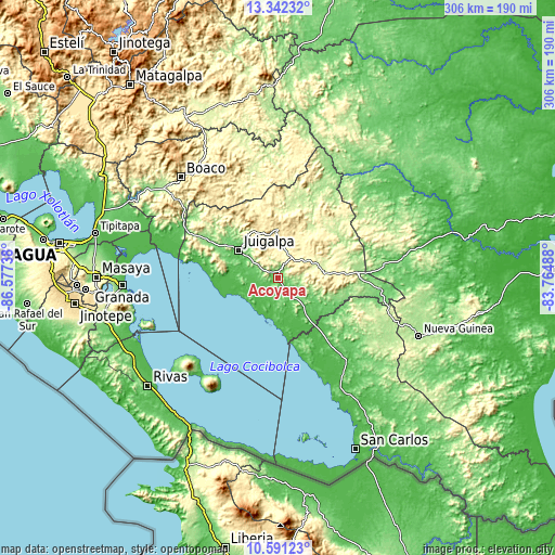
| \ | Map #1 | Map #2 | Topo.Map |
| Scale [m] | 57..375 m | 41..539 m | × |
| Scale [ft] | 187..1230 ft | 135..1768 ft | × |
| Average | 113.9 m = 374 ft | 161.9 m = 531 ft | × |
| Width | 9.56 km = 5.9 mi | 19.12 km = 11.9 mi | 305.9 km = 190.1 mi |
| Height | 9.56 km = 5.9 mi | 19.12 km = 11.9 mi | 305.9 km = 190.1 mi |
| ↑Max Latitude | 12.013266° | 12.056246° | 13.34232° |
| Latitude at center | 11.97028° | 11.97028° | 11.97028° |
| ↓Min Latitude | 11.927287° | 11.884287° | 10.59123° |
| ← Min Longitude | -85.215075° | -85.259021° | -86.57738° |
| Longitude center | -85.17113° | -85.17113° | -85.17113° |
| →Max Longitude | -85.127185° | -85.083239° | -83.76488° |
Nearby cities:
Cities around Acoyapa sort by population:
• Juigalpa elevation 123 m
25.9 km,  305°
305°
• Camoapa 571 m
59.1 km,  321°
321°
• Santo Tomás 412 m
14.1 km,  38°
38°
• Villa Sandino 306 m
21.2 km,  65°
65°
• Santo Domingo 503 m
34.1 km,  16°
16°
• El Ayote 504 m
27.6 km,  332°
332°
• La Libertad 483 m
27.4 km,  1°
1°
• Cuapa 309 m
40.3 km, 325°
• Morrito 37 m
40 km,  165°
165°
• Comalapa 273 m
50.8 km, 313°
• El Coral 127 m
57.2 km,  95°
95°
• San Pedro de Lóvago 347 m
18.7 km, 18°
Multilingual:
 En español:
Acoyapa elevación 101 m.
 En France:
Acoyapa élévation 101 m.


Sources and notes:
- [note 1] Map square and city borders are not equal. Map elevation data is calculated only from area inside that square.
- [src 1] Elevation data from geonames database provided with same terms of usage.
- [src 2] The elevation map of Acoyapa is generated using elevation data from NASA's 3 arcsec (90m) resolution SRTM data.
- [src 3] Base (background) map © OpenStreetMap contributors tiles are generated by Geofabrik and OpenTopoMap.
Copyright & License:
This Acoyapa Elevation Map is licensed under CC BY-SA. You may reuse any part from this page, if you give a proper credit by linking to this URL:
 More info on terms of use page.