Corn Island elevation
Corn Island (South Caribbean Coast), Nicaragua elevation is 113 meters and Corn Island elevation in feet is 371 ft above sea level [src 1]. Corn Island is a seat of a second-order administrative division (feature code) with elevation that is 228 meters (748 ft) smaller than average city elevation in Nicaragua.
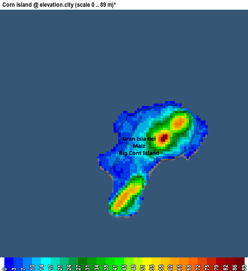
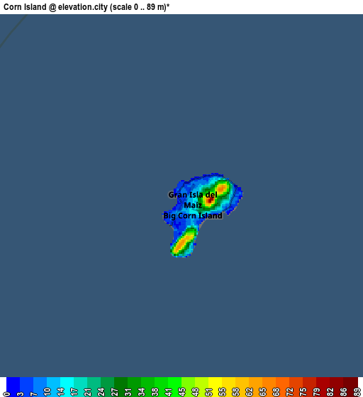
Below is the Elevation map of Corn Island, which displays elevation range with different colors. Scale of the first map is from 0 to 89 m (0 to 292 ft) with average elevation of 19.6 meters (=64 ft) [note 1]
These maps also provides idea of topography and contour of this city, they are displayed at different zoom levels. More info about maps, scale and edge coordinates you can find below images.
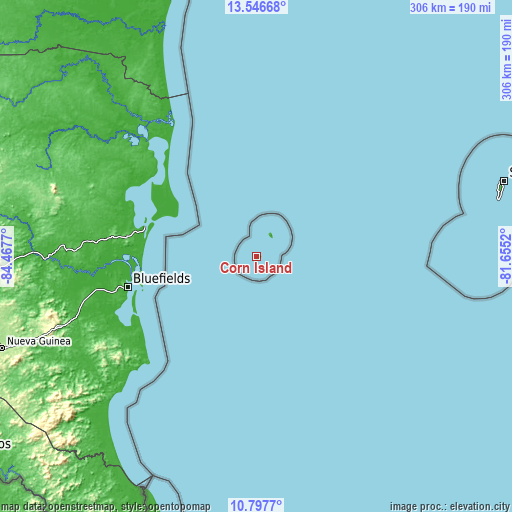
| \ | Map #1 | Map #2 | Topo.Map |
| Scale [m] | 0..89 m | 0..89 m | × |
| Scale [ft] | 0..292 ft | 0..292 ft | × |
| Average | 19.6 m = 64 ft | 19.6 m = 64 ft | × |
| Width | 9.55 km = 5.9 mi | 19.11 km = 11.9 mi | 305.7 km = 190 mi |
| Height | 9.55 km = 5.9 mi | 19.11 km = 11.9 mi | 305.7 km = 190 mi |
| ↑Max Latitude | 12.218703° | 12.26165° | 13.54668° |
| Latitude at center | 12.17575° | 12.17575° | 12.17575° |
| ↓Min Latitude | 12.13279° | 12.089823° | 10.7977° |
| ← Min Longitude | -83.105395° | -83.149341° | -84.4677° |
| Longitude center | -83.06145° | -83.06145° | -83.06145° |
| →Max Longitude | -83.017505° | -82.973559° | -81.6552° |
Nearby cities:
Cities around Corn Island sort by population:
• Nueva Guinea elevation 212 m
161.1 km,  250°
250°
• Bluefields 16 m
78.4 km,  256°
256°
• El Rama 14 m
125.9 km,  269°
269°
• Laguna de Perlas 10 m
68.8 km,  285°
285°
• Muelle de los Bueyes 74 m
160.6 km, 265°
• La Cruz de Río Grande 23 m
160.4 km,  310°
310°
• El Tortuguero 15 m
142.6 km,  300°
300°
• Greytown 1 m
155.1 km,  208°
208°
• Prinzapolka 4 m
147.4 km,  338°
338°
• El Coral 127 m
174.9 km, 260°
• Karawala 11 m
100.9 km,  326°
326°
• Kukrahill 33 m
74.7 km,  275°
275°
Multilingual:
 En español:
Corn Island elevación 113 m.
 En France:
Corn Island élévation 113 m.
 Auf Deutsch:
Corn Island höhe über dem Meeresspiegel ist 113 m.

Sources and notes:
- [note 1] Map square and city borders are not equal. Map elevation data is calculated only from area inside that square.
- [src 1] Elevation data from geonames database provided with same terms of usage.
- [src 2] The elevation map of Corn Island is generated using elevation data from NASA's 3 arcsec (90m) resolution SRTM data.
- [src 3] Base (background) map © OpenStreetMap contributors tiles are generated by Geofabrik and OpenTopoMap.
Copyright & License:
This Corn Island Elevation Map is licensed under CC BY-SA. You may reuse any part from this page, if you give a proper credit by linking to this URL:
 More info on terms of use page.