El Rama elevation
El Rama (South Caribbean Coast), Nicaragua elevation is 14 meters and El Rama elevation in feet is 46 ft above sea level [src 1]. El Rama is a seat of a second-order administrative division (feature code) with elevation that is 327 meters (1073 ft) smaller than average city elevation in Nicaragua.
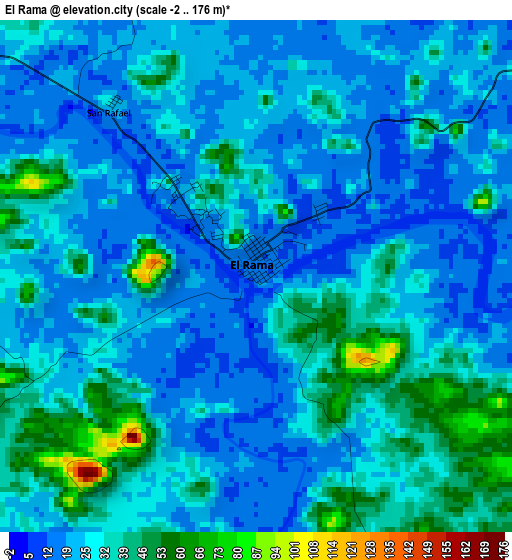
Below is the Elevation map of El Rama, which displays elevation range with different colors. Scale of the first map is from -2 to 176 m (-7 to 577 ft) with average elevation of 27.9 meters (=92 ft) [note 1]
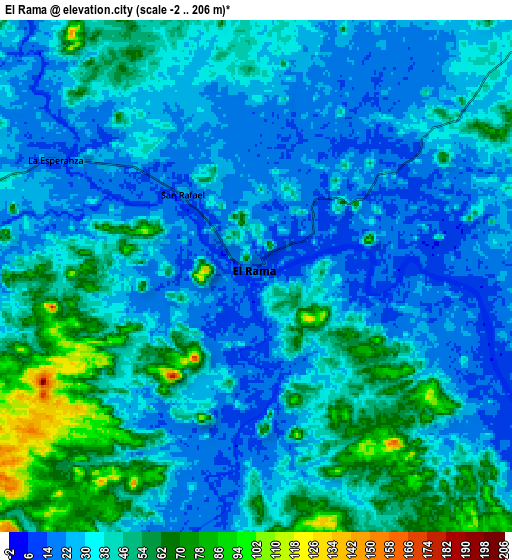
These maps also provides idea of topography and contour of this city, they are displayed at different zoom levels. More info about maps, scale and edge coordinates you can find below images.
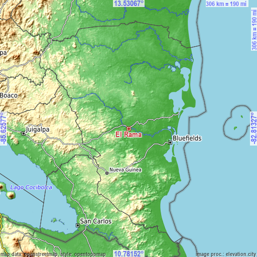
| \ | Map #1 | Map #2 | Topo.Map |
| Scale [m] | -2..176 m | -2..206 m | × |
| Scale [ft] | -7..577 ft | -7..676 ft | × |
| Average | 27.9 m = 92 ft | 36.6 m = 120 ft | × |
| Width | 9.55 km = 5.9 mi | 19.11 km = 11.9 mi | 305.7 km = 190 mi |
| Height | 9.55 km = 5.9 mi | 19.11 km = 11.9 mi | 305.7 km = 190 mi |
| ↑Max Latitude | 12.202606° | 12.245555° | 13.53067° |
| Latitude at center | 12.15965° | 12.15965° | 12.15965° |
| ↓Min Latitude | 12.116687° | 12.073717° | 10.78152° |
| ← Min Longitude | -84.263465° | -84.307411° | -85.62577° |
| Longitude center | -84.21952° | -84.21952° | -84.21952° |
| →Max Longitude | -84.175575° | -84.131629° | -82.81327° |
Nearby cities:
Cities around El Rama sort by population:
• Nueva Guinea elevation 212 m
58.5 km,  206°
206°
• Bluefields 16 m
52.2 km,  108°
108°
• Santo Tomás 412 m
95.2 km,  263°
263°
• Villa Sandino 306 m
85.1 km, 261°
• Laguna de Perlas 10 m
63 km,  71°
71°
• Santo Domingo 503 m
94.5 km,  277°
277°
• Muelle de los Bueyes 74 m
35.7 km,  253°
253°
• El Almendro 175 m
75 km,  224°
224°
• El Tortuguero 15 m
73.7 km,  1°
1°
• El Ayote 138 m
74.9 km,  300°
300°
• El Coral 127 m
53.8 km,  240°
240°
• Kukrahill 33 m
52.3 km,  80°
80°
Multilingual:
 En español:
El Rama elevación 14 m.
 En France:
El Rama élévation 14 m.


Sources and notes:
- [note 1] Map square and city borders are not equal. Map elevation data is calculated only from area inside that square.
- [src 1] Elevation data from geonames database provided with same terms of usage.
- [src 2] The elevation map of El Rama is generated using elevation data from NASA's 3 arcsec (90m) resolution SRTM data.
- [src 3] Base (background) map © OpenStreetMap contributors tiles are generated by Geofabrik and OpenTopoMap.
Copyright & License:
This El Rama Elevation Map is licensed under CC BY-SA. You may reuse any part from this page, if you give a proper credit by linking to this URL:
 More info on terms of use page.