San Lucas elevation
San Lucas (Madriz), Nicaragua elevation is 789 meters and San Lucas elevation in feet is 2589 ft above sea level [src 1]. San Lucas is a seat of a second-order administrative division (feature code) with elevation that is 448 meters (1470 ft) bigger than average city elevation in Nicaragua.
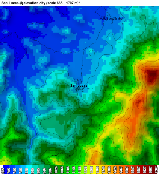
Below is the Elevation map of San Lucas, which displays elevation range with different colors. Scale of the first map is from 665 to 1707 m (2182 to 5600 ft) with average elevation of 945 meters (=3100 ft) [note 1]
These maps also provides idea of topography and contour of this city, they are displayed at different zoom levels. More info about maps, scale and edge coordinates you can find below images.
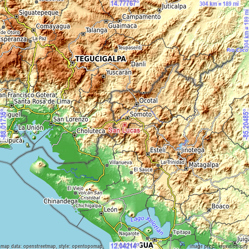
| \ | Map #1 | Topo.Map |
| Scale [m] | 665..1707 m | × |
| Scale [ft] | 2182..5600 ft | × |
| Average | 945 m = 3100 ft | × |
| Width | 9.51 km = 5.9 mi | 304.2 km = 189 mi |
| Height | 9.51 km = 5.9 mi | 304.2 km = 189 mi |
| ↑Max Latitude | 13.456543° | 14.77767° |
| Latitude at center | 13.4138° | 13.4138° |
| ↓Min Latitude | 13.37105° | 12.04214° |
| ← Min Longitude | -86.655045° | -88.01735° |
| Longitude center | -86.6111° | -86.6111° |
| →Max Longitude | -86.567155° | -85.20485° |
Nearby cities:
Cities around San Lucas sort by population:
• Ocotal elevation 611 m
28.4 km,  31°
31°
• Somoto 711 m
8.1 km,  22°
22°
• Condega 559 m
23.6 km,  103°
103°
• San Juan de Limay 284 m
26.4 km,  180°
180°
• Pueblo Nuevo 612 m
14.6 km, 104°
• Palacagüina 545 m
22.6 km,  78°
78°
• Totogalpa 690 m
21 km,  37°
37°
• Yalagüina 640 m
15 km,  58°
58°
• San José de Cusmapa 1288 m
14.7 km,  198°
198°
• Las Sabanas 1252 m
8 km,  188°
188°
• Macuelizo 694 m
26.6 km,  359°
359°
• San Francisco del Norte 394 m
29.5 km,  215°
215°
Multilingual:
 En español:
San Lucas elevación 789 m.
 En France:
San Lucas élévation 789 m.
 Auf Deutsch:
San Lucas höhe über dem Meeresspiegel ist 789 m.

Sources and notes:
- [note 1] Map square and city borders are not equal. Map elevation data is calculated only from area inside that square.
- [src 1] Elevation data from geonames database provided with same terms of usage.
- [src 2] The elevation map of San Lucas is generated using elevation data from NASA's 3 arcsec (90m) resolution SRTM data.
- [src 3] Base (background) map © OpenStreetMap contributors tiles are generated by Geofabrik and OpenTopoMap.
Copyright & License:
This San Lucas Elevation Map is licensed under CC BY-SA. You may reuse any part from this page, if you give a proper credit by linking to this URL:
 More info on terms of use page.