Ocotal elevation
Ocotal (Nueva Segovia), Nicaragua elevation is 611 meters and Ocotal elevation in feet is 2005 ft above sea level [src 1]. Ocotal is a seat of a first-order administrative division (feature code) with elevation that is 270 meters (886 ft) bigger than average city elevation in Nicaragua.
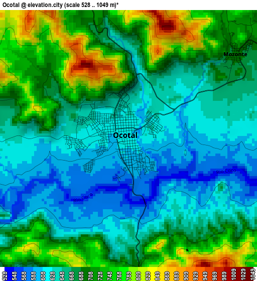
Below is the Elevation map of Ocotal, which displays elevation range with different colors. Scale of the first map is from 528 to 1049 m (1732 to 3442 ft) with average elevation of 680.9 meters (=2234 ft) [note 1]
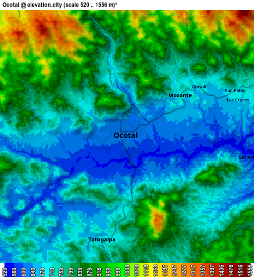
These maps also provides idea of topography and contour of this city, they are displayed at different zoom levels. More info about maps, scale and edge coordinates you can find below images.
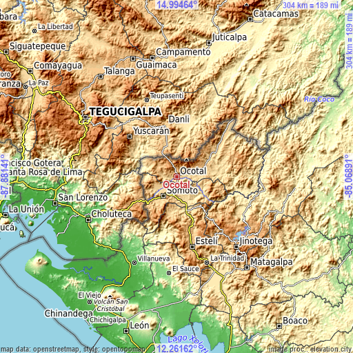
| \ | Map #1 | Map #2 | Topo.Map |
| Scale [m] | 528..1049 m | 520..1556 m | × |
| Scale [ft] | 1732..3442 ft | 1706..5105 ft | × |
| Average | 680.9 m = 2234 ft | 794.1 m = 2605 ft | × |
| Width | 9.5 km = 5.9 mi | 18.99 km = 11.8 mi | 303.9 km = 188.8 mi |
| Height | 9.5 km = 5.9 mi | 18.99 km = 11.8 mi | 303.9 km = 188.8 mi |
| ↑Max Latitude | 13.674783° | 13.717479° | 14.99464° |
| Latitude at center | 13.63208° | 13.63208° | 13.63208° |
| ↓Min Latitude | 13.589369° | 13.54665° | 12.26162° |
| ← Min Longitude | -86.519105° | -86.563051° | -87.88141° |
| Longitude center | -86.47516° | -86.47516° | -86.47516° |
| →Max Longitude | -86.431215° | -86.387269° | -85.06891° |
Nearby cities:
Cities around Ocotal sort by population:
• Somoto elevation 711 m
20.4 km,  214°
214°
• Pueblo Nuevo 612 m
28.1 km,  181°
181°
• San Fernando 733 m
18 km,  73°
73°
• Palacagüina 545 m
21 km,  159°
159°
• Mozonte 697 m
5.1 km,  51°
51°
• Yalagüina 640 m
16.6 km,  186°
186°
• Totogalpa 690 m
7.9 km, 193°
• Telpaneca 499 m
23.2 km,  118°
118°
• Ciudad Antigua 634 m
18.1 km,  86°
86°
• Santa María 778 m
28.3 km,  296°
296°
• Dipilto 917 m
10.4 km,  341°
341°
• Macuelizo 694 m
15.1 km,  278°
278°
Multilingual:
 En español:
Ocotal elevación 611 m.
 En France:
Ocotal élévation 611 m.


Sources and notes:
- [note 1] Map square and city borders are not equal. Map elevation data is calculated only from area inside that square.
- [src 1] Elevation data from geonames database provided with same terms of usage.
- [src 2] The elevation map of Ocotal is generated using elevation data from NASA's 3 arcsec (90m) resolution SRTM data.
- [src 3] Base (background) map © OpenStreetMap contributors tiles are generated by Geofabrik and OpenTopoMap.
Copyright & License:
This Ocotal Elevation Map is licensed under CC BY-SA. You may reuse any part from this page, if you give a proper credit by linking to this URL:
 More info on terms of use page.